
 Gilserberg
Berlin
Bordesholm
Bechtolsheim
Aub
Triptis
Heppenheim
Biblis
Angermünde
Gilserberg
Berlin
Bordesholm
Bechtolsheim
Aub
Triptis
Heppenheim
Biblis
Angermünde
Heilig Kreuz on the map, Landsberg am Lech, Germany
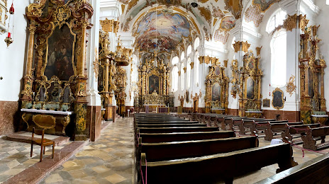
Photo
Where is located Heilig Kreuz
Heilig Kreuz — local attraction, which is located at Von-Helfenstein-Gasse 427B, 86899 Landsberg am Lech, Germany and belongs to the category — catholic church. Average visitor rating for this place — 4.5 (according to 56 ratings, information from open sources and relevant for 2022).
Exact location — Heilig Kreuz, marked on the map with a red marker.
You can get directions to Heilig Kreuz on the map from your location.
What else is interesting in Landsberg am Lech? You can see all the sights if you go to the city page.
Coordinates
Heilig Kreuz, Germany coordinates in decimal format: latitude — 48.07881918488913, longitude — 10.890314534887452. When converted to degrees, minutes, seconds Heilig Kreuz has the following coordinates: 48°4′43.75 north latitude and 10°53′25.13 east longitude.
Nearby cities
The largest cities that are located nearby:
- Augsburg — 35 km
- Munich — 53 km
- Ulm — 75 km
- Ingolstadt — 89 km
- Innsbruck
 (Austria) — 95 km
 - Reutlingen — 132 km
- Regensburg — 139 km
- Stuttgart — 147 km
- Nuremberg — 156 km
- Fürth — 158 km
- Salzburg (Austria) — 164 km
- Heilbronn — 170 km
- Erlangen — 170 km
- Pforzheim — 183 km
- Zurich
 (Switzerland) — 190 km
 - Würzburg — 203 km
- Karlsruhe — 208 km
- Heidelberg — 217 km
- Trento
 (Italy) — 220 km
Distance to the capital
Distance to the capital (Berlin) is about — 525 km.