
 Pfarrwerfen
Rosenau am Hengstpaß
Grinzens
Sankt Martin am Wöllmißberg
Sankt Martin am Silberberg
Söding
Felixdorf
Oberpullendorf District
Fließ
Pfarrwerfen
Rosenau am Hengstpaß
Grinzens
Sankt Martin am Wöllmißberg
Sankt Martin am Silberberg
Söding
Felixdorf
Oberpullendorf District
Fließ
Galitzenklamm on the map, Lienz, Austria
Photo
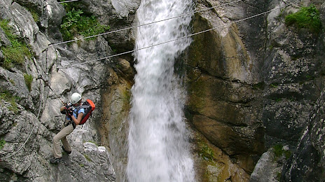
Where is located Galitzenklamm
Galitzenklamm — local attraction, which is located at no data and belongs to the category — -. Average visitor rating for this place — 4.6 (according to 29 ratings, information from open sources and relevant for 2022).
Exact location — Galitzenklamm, marked on the map with a red marker.
You can get directions to Galitzenklamm on the map from your location.
What else is interesting in Lienz? You can see all the sights if you go to the city page.
Coordinates
Galitzenklamm, Austria coordinates in decimal format: latitude — 46.79056697101356, longitude — 12.766151598233117. When converted to degrees, minutes, seconds Galitzenklamm has the following coordinates: 46°47′26.04 north latitude and 12°45′58.15 east longitude.
Nearby cities
The largest cities that are located nearby:
- Salzburg — 111 km
- Innsbruck — 113 km
- Trento
 (Italy) — 151 km
 - Trieste (Italy) — 152 km
- Venice (Italy) — 157 km
- Ljubljana
 (Slovenia) — 159 km
 - Munich
 (Germany) — 169 km
 - Vicenza (Italy) — 171 km
- Linz — 198 km
- Graz — 203 km
- Verona (Italy) — 206 km
- Rijeka
 (Croatia) — 211 km
 - Augsburg (Germany) — 219 km
- Ingolstadt (Germany) — 235 km
- Ferrara (Italy) — 238 km
- Brescia (Italy) — 243 km
- Regensburg (Germany) — 246 km
- Ulm (Germany) — 268 km
- Bergamo (Italy) — 269 km
Distance to the capital
Distance to the capital (Vienna) is about — 314 km.