
 Pfarrwerfen
Rosenau am Hengstpaß
Grinzens
Sankt Martin am Wöllmißberg
Sankt Martin am Silberberg
Söding
Felixdorf
Oberpullendorf District
Fließ
Pfarrwerfen
Rosenau am Hengstpaß
Grinzens
Sankt Martin am Wöllmißberg
Sankt Martin am Silberberg
Söding
Felixdorf
Oberpullendorf District
Fließ
Gschwandtkopf (Seefeld) on the map, Telfs, Austria
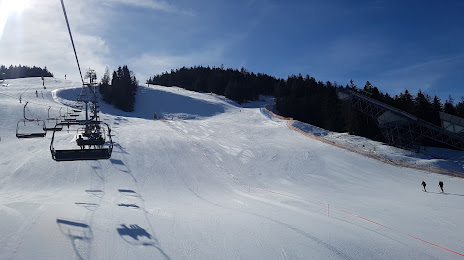
Photo
Where is located Gschwandtkopf (Seefeld)
Gschwandtkopf (Seefeld) — local attraction, which is located at Gschwandtkopf 702, 6100 Seefeld in Tirol, Austria and belongs to the category — ski resort. Average visitor rating for this place — 4.5 (according to 566 ratings, information from open sources and relevant for 2022).
Exact location — Gschwandtkopf (Seefeld), marked on the map with a red marker.
You can get directions to Gschwandtkopf (Seefeld) on the map from your location.
What else is interesting in Telfs? You can see all the sights if you go to the city page.
Coordinates
Gschwandtkopf (Seefeld), Austria coordinates in decimal format: latitude — 47.32507505332154, longitude — 11.178722725170227. When converted to degrees, minutes, seconds Gschwandtkopf (Seefeld) has the following coordinates: 47°19′30.27 north latitude and 11°10′43.4 east longitude.
Nearby cities
The largest cities that are located nearby:
- Innsbruck — 26 km
- Munich
 (Germany) — 99 km
 - Augsburg (Germany) — 118 km
- Trento
 (Italy) — 137 km
 - Ulm (Germany) — 145 km
- Salzburg — 158 km
- Ingolstadt (Germany) — 163 km
- Zurich
 (Switzerland) — 190 km
 - Reutlingen (Germany) — 190 km
- Vicenza (Italy) — 198 km
- Regensburg (Germany) — 203 km
- Brescia (Italy) — 206 km
- Verona (Italy) — 207 km
- Bergamo (Italy) — 208 km
- Stuttgart (Germany) — 213 km
- Venice (Italy) — 228 km
- Monza (Italy) — 236 km
- Nuremberg (Germany) — 237 km
- Fürth (Germany) — 240 km
Distance to the capital
Distance to the capital (Vienna) is about — 401 km.