
 Ardena
Apiro
Cozzuolo
Amendolea
Grimaldi
Pignano
Case Nuove Russo
Palazzo
Lido di Rivoli
Ardena
Apiro
Cozzuolo
Amendolea
Grimaldi
Pignano
Case Nuove Russo
Palazzo
Lido di Rivoli
Castello di Stigliano on the map, Salzano, Italy
Photo
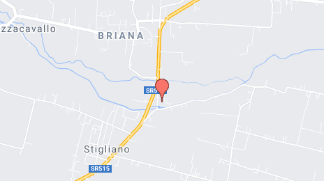
Where is located Castello di Stigliano
Castello di Stigliano — local attraction, which is located at 30036 Santa Maria di Sala, Metropolitan City of Venice, Italy and belongs to the category — fortress. Average visitor rating for this place — 4.8 (according to 9 ratings, information from open sources and relevant for 2022).
Exact location — Castello di Stigliano, marked on the map with a red marker.
You can get directions to Castello di Stigliano on the map from your location.
What else is interesting in Salzano? You can see all the sights if you go to the city page.
Coordinates
Castello di Stigliano, Italy coordinates in decimal format: latitude — 45.52731305579922, longitude — 12.05146952510896. When converted to degrees, minutes, seconds Castello di Stigliano has the following coordinates: 45°31′38.33 north latitude and 12°3′5.29 east longitude.
Nearby cities
The largest cities that are located nearby:
- Venice — 19 km
- Vicenza — 44 km
- Ferrara — 85 km
- Verona — 87 km
- Trento — 97 km
- Ravenna — 122 km
- Bologna — 128 km
- Trieste — 130 km
- Modena — 134 km
- Forli — 144 km
- Brescia — 147 km
- Parma — 160 km
- Rimini — 165 km
- Rijeka
 (Croatia) — 183 km
 - Bergamo — 188 km
- Ljubljana
 (Slovenia) — 194 km
 - Prato — 198 km
- Innsbruck
 (Austria) — 200 km
 - Florence — 205 km
Distance to the capital
Distance to the capital (Rome) is about — 405 km.