
 Ardena
Apiro
Cozzuolo
Amendolea
Grimaldi
Pignano
Case Nuove Russo
Palazzo
Lido di Rivoli
Ardena
Apiro
Cozzuolo
Amendolea
Grimaldi
Pignano
Case Nuove Russo
Palazzo
Lido di Rivoli
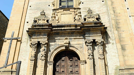
Chiesa di San Rocco on the map, Piazza Armerina, Italy
Photo
Where is located Chiesa di San Rocco
Chiesa di San Rocco — local attraction, which is located at Via Camillo Benso Conte di Cavour, 2, 94015 Piazza Armerina EN, Italy and belongs to the category — catholic church. Average visitor rating for this place — 3.6 (according to 5 ratings, information from open sources and relevant for 2022).
Exact location — Chiesa di San Rocco, marked on the map with a red marker.
You can get directions to Chiesa di San Rocco on the map from your location.
What else is interesting in Piazza Armerina? You can see all the sights if you go to the city page.
Coordinates
Chiesa di San Rocco, Italy coordinates in decimal format: latitude — 37.38447351774893, longitude — 14.365509924855878. When converted to degrees, minutes, seconds Chiesa di San Rocco has the following coordinates: 37°23′4.1 north latitude and 14°21′55.84 east longitude.
Nearby cities
The largest cities that are located nearby:
- Catania — 64 km
- Syracuse — 88 km
- Palermo — 119 km
- Messina — 136 km
- Reggio Calabria — 137 km
- Salerno — 366 km
- Tunis
 (Tunisia) — 376 km
 - Sousse (Tunisia) — 379 km
- Naples — 383 km
- Giugliano in Campania — 392 km
- Bizerte (Tunisia) — 397 km
- Taranto — 418 km
- Sfax (Tunisia) — 440 km
- Foggia — 461 km
- Bari — 462 km
- Latina — 467 km
- Cagliari — 493 km
- Djerba Midoun (Tunisia) — 500 km
- Tripoli
 (Libya) — 510 km
Distance to the capital
Distance to the capital (Rome) is about — 527 km.