
 Pfarrwerfen
Rosenau am Hengstpaß
Grinzens
Sankt Martin am Wöllmißberg
Sankt Martin am Silberberg
Söding
Felixdorf
Oberpullendorf District
Fließ
Pfarrwerfen
Rosenau am Hengstpaß
Grinzens
Sankt Martin am Wöllmißberg
Sankt Martin am Silberberg
Söding
Felixdorf
Oberpullendorf District
Fließ
Burgruine Glanegg on the map, Feldkirchen in Kärnten, Austria
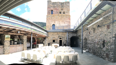
Photo
Where is located Burgruine Glanegg
Burgruine Glanegg — local attraction, which is located at Mautbrücken 1, 9555 Mautbrücken, Austria and belongs to the category — castle. Average visitor rating for this place — 4.7 (according to 99 ratings, information from open sources and relevant for 2022).
Exact location — Burgruine Glanegg, marked on the map with a red marker.
You can get directions to Burgruine Glanegg on the map from your location.
What else is interesting in Feldkirchen in Kärnten? You can see all the sights if you go to the city page.
Coordinates
Burgruine Glanegg, Austria coordinates in decimal format: latitude — 46.72663358433663, longitude — 14.1818800251496. When converted to degrees, minutes, seconds Burgruine Glanegg has the following coordinates: 46°43′35.88 north latitude and 14°10′54.77 east longitude.
Nearby cities
The largest cities that are located nearby:
- Ljubljana
 (Slovenia) — 81 km
 - Graz — 109 km
- Trieste
 (Italy) — 122 km
 - Salzburg — 142 km
- Rijeka
 (Croatia) — 157 km
 - Linz — 175 km
- Zagreb (Croatia) — 177 km
- Venice (Italy) — 198 km
- Innsbruck — 210 km
- Vicenza (Italy) — 237 km
- Trento (Italy) — 239 km
- Munich
 (Germany) — 242 km
 - Bratislava
 (Slovakia) — 272 km
 - Verona (Italy) — 279 km
- Ferrara (Italy) — 285 km
- Győr
 (Hungary) — 286 km
 - Regensburg (Germany) — 291 km
- Ravenna (Italy) — 295 km
- Augsburg (Germany) — 297 km
Distance to the capital
Distance to the capital (Vienna) is about — 233 km.