 Herbertstown
Dromagh
Roughgrove
Millstreet
County Dublin
Athy
Sallins
Ballybunnion
Fethard
Herbertstown
Dromagh
Roughgrove
Millstreet
County Dublin
Athy
Sallins
Ballybunnion
Fethard
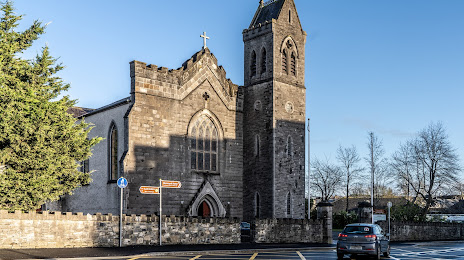
St. Mary's Catholic Church on the map, Maynooth, Ireland
Photo
Where is located St. Mary's Catholic Church
St. Mary's Catholic Church — local attraction, which is located at Moyglare Rd, Maynooth, Co. Kildare, Ireland and belongs to the category — catholic church. Average visitor rating for this place — 4.6 (according to 108 ratings, information from open sources and relevant for 2022).
Exact location — St. Mary's Catholic Church, marked on the map with a red marker.
You can get directions to St. Mary's Catholic Church on the map from your location.
What else is interesting in Maynooth? You can see all the sights if you go to the city page.
Coordinates
St. Mary's Catholic Church, Ireland coordinates in decimal format: latitude — 53.382829782787645, longitude — -6.593537674610751. When converted to degrees, minutes, seconds St. Mary's Catholic Church has the following coordinates: 53°22′58.19 north latitude and -6°35′36.74 east longitude.
Nearby cities
The largest cities that are located nearby:
- Belfast
 (United Kingdom) — 141 km
 - Cork — 209 km
- Liverpool (United Kingdom) — 237 km
- Preston (United Kingdom) — 258 km
- Blackburn (United Kingdom) — 271 km
- Manchester (United Kingdom) — 286 km
- Telford (United Kingdom) — 289 km
- Stoke-on-Trent (United Kingdom) — 297 km
- Glasgow (United Kingdom) — 311 km
- Huddersfield (United Kingdom) — 316 km
- Dudley (United Kingdom) — 318 km
- West Bromwich (United Kingdom) — 324 km
- Worcester (Great Britain) — 324 km
- Birmingham (United Kingdom) — 332 km
- Sutton Coldfield (United Kingdom) — 333 km
- Sheffield (United Kingdom) — 338 km
- Rotherham (United Kingdom) — 344 km
- Bristol (Great Britain) — 349 km
- Cheltenham (United Kingdom) — 349 km
Distance to the capital
Distance to the capital (Dublin) is about — 22 km.