
 Ardena
Apiro
Cozzuolo
Amendolea
Grimaldi
Pignano
Case Nuove Russo
Palazzo
Lido di Rivoli
Ardena
Apiro
Cozzuolo
Amendolea
Grimaldi
Pignano
Case Nuove Russo
Palazzo
Lido di Rivoli
Chiesa dei Servi on the map, Forlimpopoli, Italy
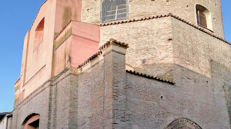
Photo
Where is located Chiesa dei Servi
Chiesa dei Servi — local attraction, which is located at Via Cesare Battisti, 47034 Forlimpopoli FC, Italy and belongs to the category — church. Average visitor rating for this place — 4.7 (according to 7 ratings, information from open sources and relevant for 2022).
Exact location — Chiesa dei Servi, marked on the map with a red marker.
You can get directions to Chiesa dei Servi on the map from your location.
What else is interesting in Forlimpopoli? You can see all the sights if you go to the city page.
Coordinates
Chiesa dei Servi, Italy coordinates in decimal format: latitude — 44.18828465996221, longitude — 12.12600872506461. When converted to degrees, minutes, seconds Chiesa dei Servi has the following coordinates: 44°11′17.82 north latitude and 12°7′33.63 east longitude.
Nearby cities
The largest cities that are located nearby:
- Forli — 8 km
- Ravenna — 26 km
- Rimini — 37 km
- Bologna — 71 km
- Ferrara — 82 km
- Florence — 84 km
- Prato — 89 km
- Modena — 108 km
- Perugia — 121 km
- Ancona — 128 km
- Venice — 139 km
- Parma — 157 km
- Vicenza — 157 km
- Livorno — 162 km
- Verona — 164 km
- Terni — 184 km
- Trieste — 206 km
- Brescia — 211 km
- Rijeka
 (Croatia) — 220 km
Distance to the capital
Distance to the capital (Rome) is about — 256 km.