
 Gilserberg
Berlin
Bordesholm
Bechtolsheim
Aub
Triptis
Heppenheim
Biblis
Angermünde
Gilserberg
Berlin
Bordesholm
Bechtolsheim
Aub
Triptis
Heppenheim
Biblis
Angermünde
Skilift Glasberg on the map, Zwiesel, Germany
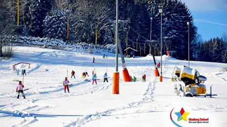
Photo
Where is located Skilift Glasberg
Skilift Glasberg — local attraction, which is located at Lohmannmühlweg 60b, 94227 Zwiesel, Germany and belongs to the category — ski resort. Average visitor rating for this place — 4.4 (according to 40 ratings, information from open sources and relevant for 2022).
Exact location — Skilift Glasberg, marked on the map with a red marker.
You can get directions to Skilift Glasberg on the map from your location.
What else is interesting in Zwiesel? You can see all the sights if you go to the city page.
Coordinates
Skilift Glasberg, Germany coordinates in decimal format: latitude — 49.00415830758341, longitude — 13.23957562522902. When converted to degrees, minutes, seconds Skilift Glasberg has the following coordinates: 49°0′14.97 north latitude and 13°14′22.47 east longitude.
Nearby cities
The largest cities that are located nearby:
- Pilsen
 (Czech Republic) — 80 km
 - Regensburg — 82 km
- Linz
 (Austria) — 110 km
 - Salzburg (Austria) — 134 km
- Ingolstadt — 135 km
- Prague (Czech Republic) — 145 km
- Munich — 156 km
- Nuremberg — 163 km
- Fürth — 169 km
- Erlangen — 172 km
- Augsburg — 186 km
- Chemnitz — 201 km
- Gera — 222 km
- Dresden — 227 km
- Innsbruck (Austria) — 237 km
- Brno (Czech Republic) — 244 km
- Vienna (Austria) — 248 km
- Ulm — 248 km
- Würzburg — 250 km
Distance to the capital
Distance to the capital (Berlin) is about — 391 km.