 Herbertstown
Dromagh
Roughgrove
Millstreet
County Dublin
Athy
Sallins
Ballybunnion
Fethard
Herbertstown
Dromagh
Roughgrove
Millstreet
County Dublin
Athy
Sallins
Ballybunnion
Fethard
Connolly's Folly on the map, Lucan, Ireland
Photo
Where is located Connolly's Folly
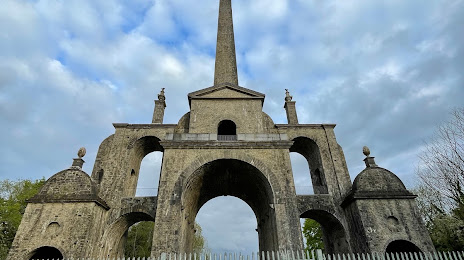
Connolly's Folly — local attraction, which is located at Barrogstown West, Co. Kildare, Ireland and belongs to the category — monument. Average visitor rating for this place — 4.3 (according to 73 ratings, information from open sources and relevant for 2022).
Exact location — Connolly's Folly, marked on the map with a red marker.
You can get directions to Connolly's Folly on the map from your location.
What else is interesting in Lucan? You can see all the sights if you go to the city page.
Coordinates
Connolly's Folly, Ireland coordinates in decimal format: latitude — 53.36938337369127, longitude — -6.559911774611227. When converted to degrees, minutes, seconds Connolly's Folly has the following coordinates: 53°22′9.78 north latitude and -6°33′35.68 east longitude.
Nearby cities
The largest cities that are located nearby:
- Belfast
 (United Kingdom) — 141 km
 - Cork — 213 km
- Liverpool (United Kingdom) — 228 km
- Preston (United Kingdom) — 249 km
- Blackburn (United Kingdom) — 263 km
- Manchester (United Kingdom) — 277 km
- Telford (United Kingdom) — 279 km
- Stoke-on-Trent (United Kingdom) — 287 km
- Huddersfield (United Kingdom) — 307 km
- Dudley (United Kingdom) — 308 km
- Glasgow (United Kingdom) — 309 km
- West Bromwich (United Kingdom) — 314 km
- Worcester (Great Britain) — 314 km
- Birmingham (United Kingdom) — 322 km
- Sutton Coldfield (United Kingdom) — 323 km
- Sheffield (United Kingdom) — 328 km
- Rotherham (United Kingdom) — 335 km
- Cheltenham (United Kingdom) — 339 km
- Bristol (Great Britain) — 339 km
Distance to the capital
Distance to the capital (Dublin) is about — 20 km.