
 Staden
Geest-Gerompont-Petit-Rosière
Grote Hut
Sint-Job-in-'t-Goor
Deidenberg
De Pinte
Pussemange
Peruwelz
Barrière de Champlon
Staden
Geest-Gerompont-Petit-Rosière
Grote Hut
Sint-Job-in-'t-Goor
Deidenberg
De Pinte
Pussemange
Peruwelz
Barrière de Champlon
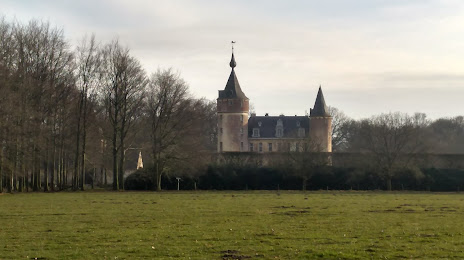
Castle 's-Gravenwezel (Kasteel van 's-Gravenwezel) on the map, Schoten, Belgium
Photo
Where is located Castle 's-Gravenwezel (Kasteel van 's-Gravenwezel)
Castle 's-Gravenwezel (Kasteel van 's-Gravenwezel) — local attraction, which is located at Sint-Jobsteenweg 64, 2970 Schilde, Belgium and belongs to the category — castle. Average visitor rating for this place — 4.4 (according to 69 ratings, information from open sources and relevant for 2022).
Exact location — Castle 's-Gravenwezel (Kasteel van 's-Gravenwezel), marked on the map with a red marker.
You can get directions to Castle 's-Gravenwezel (Kasteel van 's-Gravenwezel) on the map from your location.
What else is interesting in Schoten? You can see all the sights if you go to the city page.
Coordinates
Castle 's-Gravenwezel (Kasteel van 's-Gravenwezel), Belgium coordinates in decimal format: latitude — 51.26140711078671, longitude — 4.568764325215775. When converted to degrees, minutes, seconds Castle 's-Gravenwezel (Kasteel van 's-Gravenwezel) has the following coordinates: 51°15′41.07 north latitude and 4°34′7.55 east longitude.
Nearby cities
The largest cities that are located nearby:
- Antwerp — 7 km
- Breda
 (Netherlands) — 42 km
 - Tilburg (Netherlands) — 53 km
- Dordrecht (Netherlands) — 64 km
- Eindhoven (Netherlands) — 70 km
- 's-Hertogenbosch (Netherlands) — 74 km
- Rotterdam (Netherlands) — 75 km
- Zoetermeer (Netherlands) — 90 km
- Namur — 90 km
- The Hague (Netherlands) — 92 km
- Charleroi — 93 km
- Maastricht (Netherlands) — 94 km
- Leiden (Netherlands) — 101 km
- Liège — 102 km
- Utrecht (Netherlands) — 102 km
- Nijmegen (Netherlands) — 111 km
- Amersfoort (Netherlands) — 117 km
- Hoofddorp (Netherlands) — 118 km
- Ede (Netherlands) — 118 km
Distance to the capital
Distance to the capital (Brussels) is about — 48 km.