 Staden
Geest-Gerompont-Petit-Rosière
Grote Hut
Sint-Job-in-'t-Goor
Deidenberg
De Pinte
Pussemange
Peruwelz
Barrière de Champlon
Staden
Geest-Gerompont-Petit-Rosière
Grote Hut
Sint-Job-in-'t-Goor
Deidenberg
De Pinte
Pussemange
Peruwelz
Barrière de Champlon
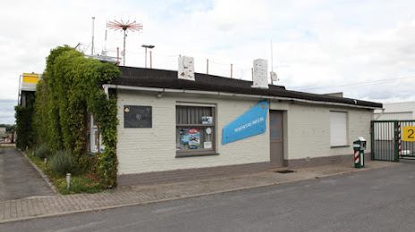
Flanders Aviation Society - Expo on the map, Wevelgem, Belgium
Photo
Where is located Flanders Aviation Society - Expo
Flanders Aviation Society - Expo — local attraction, which is located at Luchthavenstraat 1b2, 8560 Wevelgem, Belgium and belongs to the category — museum. Average visitor rating for this place — 4.6 (according to 5 ratings, information from open sources and relevant for 2022).
Exact location — Flanders Aviation Society - Expo, marked on the map with a red marker.
You can get directions to Flanders Aviation Society - Expo on the map from your location.
What else is interesting in Wevelgem? You can see all the sights if you go to the city page.
Coordinates
Flanders Aviation Society - Expo, Belgium coordinates in decimal format: latitude — 50.82032348959502, longitude — 3.2183541251996624. When converted to degrees, minutes, seconds Flanders Aviation Society - Expo has the following coordinates: 50°49′13.16 north latitude and 3°13′6.07 east longitude.
Nearby cities
The largest cities that are located nearby:
- Lille
 (France) — 22 km
 - Antwerp — 96 km
- Charleroi — 99 km
- Amiens (France) — 119 km
- Namur — 125 km
- Breda
 (Netherlands) — 139 km
 - Dordrecht (Netherlands) — 151 km
- Rotterdam (Netherlands) — 152 km
- Tilburg (Netherlands) — 155 km
- The Hague (Netherlands) — 159 km
- Zoetermeer (Netherlands) — 165 km
- Liège — 169 km
- Eindhoven (Netherlands) — 172 km
- Leiden (Netherlands) — 174 km
- Maastricht (Netherlands) — 175 km
- 's-Hertogenbosch (Netherlands) — 175 km
- Reims (France) — 182 km
- Southend-on-Sea
 (United Kingdom) — 189 km
 - Gillingham (United Kingdom) — 193 km
Distance to the capital
Distance to the capital (Brussels) is about — 80 km.