 Staden
Geest-Gerompont-Petit-Rosière
Grote Hut
Sint-Job-in-'t-Goor
Deidenberg
De Pinte
Pussemange
Peruwelz
Barrière de Champlon
Staden
Geest-Gerompont-Petit-Rosière
Grote Hut
Sint-Job-in-'t-Goor
Deidenberg
De Pinte
Pussemange
Peruwelz
Barrière de Champlon
Sint-Niklaaskerk Oostduinkerke (Sint-Niklaaskerk van Oostduinkerke) on the map, Koksijde, Belgium
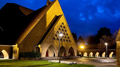
Photo
Where is located Sint-Niklaaskerk Oostduinkerke (Sint-Niklaaskerk van Oostduinkerke)
Sint-Niklaaskerk Oostduinkerke (Sint-Niklaaskerk van Oostduinkerke) — local attraction, which is located at Leopold II Laan 85, 8670 Koksijde, Belgium and belongs to the category — catholic church. Average visitor rating for this place — 4.3 (according to 82 ratings, information from open sources and relevant for 2022).
Exact location — Sint-Niklaaskerk Oostduinkerke (Sint-Niklaaskerk van Oostduinkerke), marked on the map with a red marker.
You can get directions to Sint-Niklaaskerk Oostduinkerke (Sint-Niklaaskerk van Oostduinkerke) on the map from your location.
What else is interesting in Koksijde? You can see all the sights if you go to the city page.
Coordinates
Sint-Niklaaskerk Oostduinkerke (Sint-Niklaaskerk van Oostduinkerke), Belgium coordinates in decimal format: latitude — 51.12014080770041, longitude — 2.678321625210627. When converted to degrees, minutes, seconds Sint-Niklaaskerk Oostduinkerke (Sint-Niklaaskerk van Oostduinkerke) has the following coordinates: 51°7′12.51 north latitude and 2°40′41.96 east longitude.
Nearby cities
The largest cities that are located nearby:
- Lille
 (France) — 60 km
 - Antwerp — 122 km
- Amiens (France) — 136 km
- Southend-on-Sea
 (United Kingdom) — 142 km
 - Ipswich (United Kingdom) — 147 km
- Charleroi — 148 km
- Gillingham (United Kingdom) — 148 km
- Rotterdam
 (Netherlands) — 154 km
 - The Hague (Netherlands) — 155 km
- Breda (Netherlands) — 155 km
- Basildon (United Kingdom) — 157 km
- Dordrecht (Netherlands) — 160 km
- Zoetermeer (Netherlands) — 164 km
- Chelmsford (United Kingdom) — 165 km
- Eastbourne (United Kingdom) — 169 km
- Leiden (Netherlands) — 171 km
- Namur — 172 km
- Tilburg (Netherlands) — 175 km
- Hoofddorp (Netherlands) — 191 km
Distance to the capital
Distance to the capital (Brussels) is about — 121 km.