 Betteshanger
Lynton
Amesbury
Marlow
Burford
Chipping Norton
Marlborough
Cairnryan
Lydney
Betteshanger
Lynton
Amesbury
Marlow
Burford
Chipping Norton
Marlborough
Cairnryan
Lydney
National Trust - Stoneacre on the map, Maidstone, United Kingdom
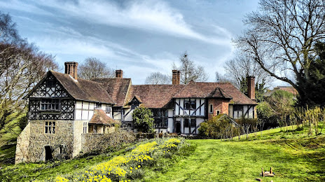
Photo
Where is located National Trust - Stoneacre
National Trust - Stoneacre — local attraction, which is located at Stoneacre Ln, Maidstone ME15 8RS, United Kingdom and belongs to the category — $$. Average visitor rating for this place — 4.4 (according to 85 ratings, information from open sources and relevant for 2022).
Exact location — National Trust - Stoneacre, marked on the map with a red marker.
You can get directions to National Trust - Stoneacre on the map from your location.
What else is interesting in Maidstone? You can see all the sights if you go to the city page.
Coordinates
National Trust - Stoneacre, United Kingdom coordinates in decimal format: latitude — 51.25202410393329, longitude — 0.5777123252154563. When converted to degrees, minutes, seconds National Trust - Stoneacre has the following coordinates: 51°15′7.29 north latitude and 0°34′39.76 east longitude.
Nearby cities
The largest cities that are located nearby:
- Gillingham — 13 km
- Southend-on-Sea — 33 km
- Basildon — 34 km
- Sutton — 50 km
- Chelmsford — 52 km
- Crawley — 52 km
- Eastbourne — 58 km
- Watford — 76 km
- Slough — 81 km
- Luton — 93 km
- Ipswich — 97 km
- Reading — 105 km
- Cambridge — 107 km
- Portsmouth — 123 km
- Oxford — 133 km
- Southampton — 140 km
- Northampton — 144 km
- Norwich — 159 km
- Swindon — 161 km
Distance to the capital
Distance to the capital (London) is about — 57 km.