 Betteshanger
Lynton
Amesbury
Marlow
Burford
Chipping Norton
Marlborough
Cairnryan
Lydney
Betteshanger
Lynton
Amesbury
Marlow
Burford
Chipping Norton
Marlborough
Cairnryan
Lydney
National Trust - St John's Jerusalem on the map, Tilbury, United Kingdom
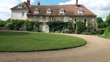
Photo
Where is located National Trust - St John's Jerusalem
National Trust - St John's Jerusalem — local attraction, which is located at Sutton at Hone, Dartford DA4 9HQ, United Kingdom and belongs to the category — $$. Average visitor rating for this place — 4.2 (according to 23 ratings, information from open sources and relevant for 2022).
Exact location — National Trust - St John's Jerusalem, marked on the map with a red marker.
You can get directions to National Trust - St John's Jerusalem on the map from your location.
What else is interesting in Tilbury? You can see all the sights if you go to the city page.
Coordinates
National Trust - St John's Jerusalem, United Kingdom coordinates in decimal format: latitude — 51.41075781999501, longitude — 0.24008352522125972. When converted to degrees, minutes, seconds National Trust - St John's Jerusalem has the following coordinates: 51°24′38.73 north latitude and 0°14′24.3 east longitude.
Nearby cities
The largest cities that are located nearby:
- Basildon — 15 km
- Gillingham — 16 km
- Southend-on-Sea — 26 km
- Chelmsford — 31 km
- Sutton — 40 km
- Crawley — 55 km
- Watford — 56 km
- Slough — 66 km
- Luton — 70 km
- Eastbourne — 77 km
- Cambridge — 84 km
- Ipswich — 85 km
- Reading — 92 km
- Oxford — 115 km
- Northampton — 121 km
- Portsmouth — 124 km
- Southampton — 137 km
- Norwich — 144 km
- Swindon — 147 km
Distance to the capital
Distance to the capital (London) is about — 28 km.