 Betteshanger
Lynton
Amesbury
Marlow
Burford
Chipping Norton
Marlborough
Cairnryan
Lydney
Betteshanger
Lynton
Amesbury
Marlow
Burford
Chipping Norton
Marlborough
Cairnryan
Lydney
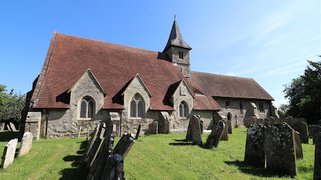
St Thomas a Becket Church on the map, Havant, United Kingdom
Photo
Where is located St Thomas a Becket Church
St Thomas a Becket Church — local attraction, which is located at Church Ln, Warblington, Havant PO9 2TU, United Kingdom and belongs to the category — anglican church. Average visitor rating for this place — 4.7 (according to 31 rating, information from open sources and relevant for 2022).
Exact location — St Thomas a Becket Church, marked on the map with a red marker.
You can get directions to St Thomas a Becket Church on the map from your location.
What else is interesting in Havant? You can see all the sights if you go to the city page.
Coordinates
St Thomas a Becket Church, United Kingdom coordinates in decimal format: latitude — 50.843696506564754, longitude — -0.9661185747994531. When converted to degrees, minutes, seconds St Thomas a Becket Church has the following coordinates: 50°50′37.31 north latitude and -0°57′58.03 east longitude.
Nearby cities
The largest cities that are located nearby:
- Portsmouth — 8 km
- Southampton — 30 km
- Crawley — 62 km
- Bournemouth — 64 km
- Reading — 67 km
- Slough — 78 km
- Sutton — 78 km
- Eastbourne — 90 km
- Swindon — 95 km
- Watford — 98 km
- Oxford — 101 km
- Luton — 120 km
- Gillingham — 121 km
- Bristol — 129 km
- Basildon — 129 km
- Cheltenham — 138 km
- Southend-on-Sea — 139 km
- Chelmsford — 139 km
- Northampton — 154 km
Distance to the capital
Distance to the capital (London) is about — 94 km.