
 Staden
Geest-Gerompont-Petit-Rosière
Grote Hut
Sint-Job-in-'t-Goor
Deidenberg
De Pinte
Pussemange
Peruwelz
Barrière de Champlon
Staden
Geest-Gerompont-Petit-Rosière
Grote Hut
Sint-Job-in-'t-Goor
Deidenberg
De Pinte
Pussemange
Peruwelz
Barrière de Champlon
Ham-sur-Heure Castle on the map, Walcourt, Belgium
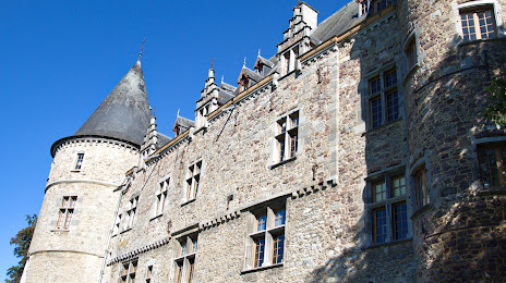
Photo
Where is located Ham-sur-Heure Castle
Ham-sur-Heure Castle — local attraction, which is located at Arrondissement de Thuin Chemin d'Oultre-Heure, 20, 6120 Ham-sur-Heure-Nalinnes, Belgium and belongs to the category — castle. Average visitor rating for this place — 4.5 (according to 97 ratings, information from open sources and relevant for 2022).
Exact location — Ham-sur-Heure Castle, marked on the map with a red marker.
You can get directions to Ham-sur-Heure Castle on the map from your location.
What else is interesting in Walcourt? You can see all the sights if you go to the city page.
Coordinates
Ham-sur-Heure Castle, Belgium coordinates in decimal format: latitude — 50.32162185393026, longitude — 4.3925694252761405. When converted to degrees, minutes, seconds Ham-sur-Heure Castle has the following coordinates: 50°19′17.84 north latitude and 4°23′33.25 east longitude.
Nearby cities
The largest cities that are located nearby:
- Charleroi — 17 km
- Namur — 39 km
- Liège — 91 km
- Lille
 (France) — 105 km
 - Antwerp — 107 km
- Maastricht
 (Netherlands) — 110 km
 - Reims (France) — 114 km
- Aachen
 (Germany) — 129 km
 - Breda (Netherlands) — 149 km
- Eindhoven (Netherlands) — 149 km
- Tilburg (Netherlands) — 151 km
- Amiens (France) — 157 km
- Trier (Germany) — 167 km
- 's-Hertogenbosch (Netherlands) — 170 km
- Mönchengladbach (Germany) — 173 km
- Dordrecht (Netherlands) — 173 km
- Metz (France) — 178 km
- Rotterdam (Netherlands) — 185 km
- Neuss (Germany) — 188 km
Distance to the capital
Distance to the capital (Brussels) is about — 59 km.