 Betteshanger
Lynton
Amesbury
Marlow
Burford
Chipping Norton
Marlborough
Cairnryan
Lydney
Betteshanger
Lynton
Amesbury
Marlow
Burford
Chipping Norton
Marlborough
Cairnryan
Lydney
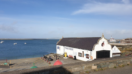
Holyhead Maritime Museum on the map, Holyhead, United Kingdom
Photo
Where is located Holyhead Maritime Museum
Holyhead Maritime Museum — local attraction, which is located at Newry Beach, Holyhead LL65 1YD, United Kingdom and belongs to the category — museum. Average visitor rating for this place — 4.5 (according to 277 ratings, information from open sources and relevant for 2022).
Exact location — Holyhead Maritime Museum, marked on the map with a red marker.
You can get directions to Holyhead Maritime Museum on the map from your location.
What else is interesting in Holyhead? You can see all the sights if you go to the city page.
Coordinates
Holyhead Maritime Museum, United Kingdom coordinates in decimal format: latitude — 53.31674373809656, longitude — -4.6357710746132295. When converted to degrees, minutes, seconds Holyhead Maritime Museum has the following coordinates: 53°19′0.28 north latitude and -4°38′8.78 east longitude.
Nearby cities
The largest cities that are located nearby:
- Dublin
 (Ireland) — 107 km
 - Liverpool — 109 km
- Preston — 136 km
- Blackburn — 148 km
- Manchester — 158 km
- Telford — 162 km
- Belfast — 165 km
- Stoke-on-Trent — 167 km
- Huddersfield — 190 km
- Dudley — 193 km
- West Bromwich — 198 km
- Worcester — 205 km
- Sutton Coldfield — 206 km
- Birmingham — 206 km
- Sheffield — 209 km
- Rotherham — 216 km
- Coventry — 233 km
- Cheltenham — 234 km
- Leicester — 246 km
Distance to the capital
Distance to the capital (London) is about — 366 km.