 Betteshanger
Lynton
Amesbury
Marlow
Burford
Chipping Norton
Marlborough
Cairnryan
Lydney
Betteshanger
Lynton
Amesbury
Marlow
Burford
Chipping Norton
Marlborough
Cairnryan
Lydney
Caer y Twr on the map, Holyhead, United Kingdom
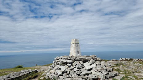
Photo
Where is located Caer y Twr
Caer y Twr — local attraction, which is located at Holyhead LL65 1YL, United Kingdom and belongs to the category — historical landmark. Average visitor rating for this place — 5.0 (according to 11 ratings, information from open sources and relevant for 2022).
Exact location — Caer y Twr, marked on the map with a red marker.
You can get directions to Caer y Twr on the map from your location.
What else is interesting in Holyhead? You can see all the sights if you go to the city page.
Coordinates
Caer y Twr, United Kingdom coordinates in decimal format: latitude — 53.31335103580324, longitude — -4.675442574613386. When converted to degrees, minutes, seconds Caer y Twr has the following coordinates: 53°18′48.06 north latitude and -4°40′31.59 east longitude.
Nearby cities
The largest cities that are located nearby:
- Dublin
 (Ireland) — 107 km
 - Liverpool — 109 km
- Preston — 136 km
- Blackburn — 148 km
- Manchester — 158 km
- Telford — 162 km
- Belfast — 165 km
- Stoke-on-Trent — 167 km
- Huddersfield — 190 km
- Dudley — 193 km
- West Bromwich — 198 km
- Worcester — 205 km
- Sutton Coldfield — 206 km
- Birmingham — 206 km
- Sheffield — 209 km
- Rotherham — 216 km
- Coventry — 233 km
- Cheltenham — 234 km
- Leicester — 246 km
Distance to the capital
Distance to the capital (London) is about — 368 km.