 Betteshanger
Lynton
Amesbury
Marlow
Burford
Chipping Norton
Marlborough
Cairnryan
Lydney
Betteshanger
Lynton
Amesbury
Marlow
Burford
Chipping Norton
Marlborough
Cairnryan
Lydney
The Vale & Downland Museum on the map, Grove, United Kingdom
Photo
Where is located The Vale & Downland Museum
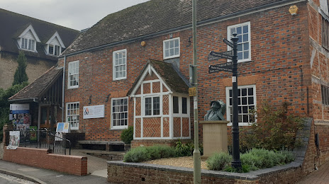
The Vale & Downland Museum — local attraction, which is located at Vale & Downland Museum & Visitor Centre, 19 Church St, Wantage OX12 8BL, United Kingdom and belongs to the category — museum. Average visitor rating for this place — 4.7 (according to 224 ratings, information from open sources and relevant for 2022).
Exact location — The Vale & Downland Museum, marked on the map with a red marker.
You can get directions to The Vale & Downland Museum on the map from your location.
What else is interesting in Grove? You can see all the sights if you go to the city page.
Coordinates
The Vale & Downland Museum, United Kingdom coordinates in decimal format: latitude — 51.981553190885705, longitude — -1.044362521621926. When converted to degrees, minutes, seconds The Vale & Downland Museum has the following coordinates: 51°58′53.59 north latitude and -1°2′39.71 east longitude.
Nearby cities
The largest cities that are located nearby:
- Oxford — 19 km
- Swindon — 26 km
- Reading — 35 km
- Cheltenham — 55 km
- Slough — 58 km
- Watford — 71 km
- Luton — 74 km
- Northampton — 78 km
- Southampton — 78 km
- Bristol — 82 km
- Worcester — 84 km
- Coventry — 88 km
- Sutton — 89 km
- Portsmouth — 91 km
- Birmingham — 102 km
- Crawley — 102 km
- Bournemouth — 104 km
- West Bromwich — 107 km
- Dudley — 109 km
Distance to the capital
Distance to the capital (London) is about — 82 km.