 Betteshanger
Lynton
Amesbury
Marlow
Burford
Chipping Norton
Marlborough
Cairnryan
Lydney
Betteshanger
Lynton
Amesbury
Marlow
Burford
Chipping Norton
Marlborough
Cairnryan
Lydney
National Trust - Hatchlands Park on the map, Guildford, United Kingdom
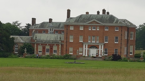
Photo
Where is located National Trust - Hatchlands Park
National Trust - Hatchlands Park — local attraction, which is located at East Clandon, Guildford GU4 7RT, United Kingdom and belongs to the category — $$. Average visitor rating for this place — 4.5 (according to 1424 ratings, information from open sources and relevant for 2022).
Exact location — National Trust - Hatchlands Park, marked on the map with a red marker.
You can get directions to National Trust - Hatchlands Park on the map from your location.
What else is interesting in Guildford? You can see all the sights if you go to the city page.
Coordinates
National Trust - Hatchlands Park, United Kingdom coordinates in decimal format: latitude — 51.25701230757662, longitude — -0.47237807478437355. When converted to degrees, minutes, seconds National Trust - Hatchlands Park has the following coordinates: 51°15′25.24 north latitude and -0°28′20.56 east longitude.
Nearby cities
The largest cities that are located nearby:
- Sutton — 29 km
- Crawley — 30 km
- Slough — 30 km
- Reading — 37 km
- Watford — 48 km
- Portsmouth — 59 km
- Southampton — 68 km
- Luton — 72 km
- Oxford — 74 km
- Gillingham — 79 km
- Eastbourne — 79 km
- Basildon — 82 km
- Chelmsford — 90 km
- Swindon — 90 km
- Southend-on-Sea — 94 km
- Bournemouth — 108 km
- Northampton — 113 km
- Cambridge — 117 km
- Cheltenham — 126 km
Distance to the capital
Distance to the capital (London) is about — 37 km.