 Staden
Geest-Gerompont-Petit-Rosière
Grote Hut
Sint-Job-in-'t-Goor
Deidenberg
De Pinte
Pussemange
Peruwelz
Barrière de Champlon
Staden
Geest-Gerompont-Petit-Rosière
Grote Hut
Sint-Job-in-'t-Goor
Deidenberg
De Pinte
Pussemange
Peruwelz
Barrière de Champlon
Oostende Pier (Pier van Oostende) on the map, Gistel, Belgium
Photo
Where is located Oostende Pier (Pier van Oostende)
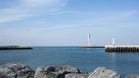
Oostende Pier (Pier van Oostende) — local attraction, which is located at 8400 Ostend, Belgium and belongs to the category — fishing pier. Average visitor rating for this place — 4.5 (according to 461 rating, information from open sources and relevant for 2022).
Exact location — Oostende Pier (Pier van Oostende), marked on the map with a red marker.
You can get directions to Oostende Pier (Pier van Oostende) on the map from your location.
What else is interesting in Gistel? You can see all the sights if you go to the city page.
Coordinates
Oostende Pier (Pier van Oostende), Belgium coordinates in decimal format: latitude — 51.23845309402242, longitude — 2.917749925214931. When converted to degrees, minutes, seconds Oostende Pier (Pier van Oostende) has the following coordinates: 51°14′18.43 north latitude and 2°55′3.9 east longitude.
Nearby cities
The largest cities that are located nearby:
- Lille
 (France) — 59 km
 - Antwerp — 100 km
- Charleroi — 133 km
- Breda
 (Netherlands) — 133 km
 - Rotterdam (Netherlands) — 133 km
- The Hague (Netherlands) — 136 km
- Dordrecht (Netherlands) — 138 km
- Zoetermeer (Netherlands) — 144 km
- Amiens (France) — 148 km
- Leiden (Netherlands) — 152 km
- Tilburg (Netherlands) — 153 km
- Namur — 154 km
- Ipswich
 (United Kingdom) — 159 km
 - Southend-on-Sea (United Kingdom) — 161 km
- Gillingham (United Kingdom) — 169 km
- 's-Hertogenbosch (Netherlands) — 171 km
- Hoofddorp (Netherlands) — 172 km
- Eindhoven (Netherlands) — 175 km
- Basildon (United Kingdom) — 177 km
Distance to the capital
Distance to the capital (Brussels) is about — 109 km.