 Betteshanger
Lynton
Amesbury
Marlow
Burford
Chipping Norton
Marlborough
Cairnryan
Lydney
Betteshanger
Lynton
Amesbury
Marlow
Burford
Chipping Norton
Marlborough
Cairnryan
Lydney
Roanhead Beach on the map, Ulverston, United Kingdom
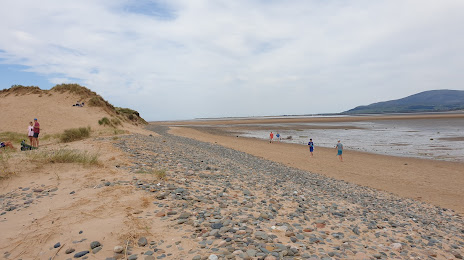
Photo
Where is located Roanhead Beach
Roanhead Beach — local attraction, which is located at no data and belongs to the category — -. Average visitor rating for this place — 4.7 (according to 427 ratings, information from open sources and relevant for 2022).
Exact location — Roanhead Beach, marked on the map with a red marker.
You can get directions to Roanhead Beach on the map from your location.
What else is interesting in Ulverston? You can see all the sights if you go to the city page.
Coordinates
Roanhead Beach, United Kingdom coordinates in decimal format: latitude — 54.16472922196067, longitude — -3.2414130206808807. When converted to degrees, minutes, seconds Roanhead Beach has the following coordinates: 54°9′53.03 north latitude and -3°14′29.09 east longitude.
Nearby cities
The largest cities that are located nearby:
- Preston — 54 km
- Blackburn — 63 km
- Liverpool — 87 km
- Manchester — 97 km
- Huddersfield — 105 km
- Sunderland — 134 km
- Sheffield — 140 km
- Rotherham — 142 km
- Stoke-on-Trent — 145 km
- Telford — 173 km
- Belfast — 187 km
- Edinburgh — 194 km
- Glasgow — 198 km
- Dudley — 198 km
- Sutton Coldfield — 199 km
- West Bromwich — 200 km
- Birmingham — 206 km
- Leicester — 216 km
- Coventry — 224 km
Distance to the capital
Distance to the capital (London) is about — 362 km.