 Betteshanger
Lynton
Amesbury
Marlow
Burford
Chipping Norton
Marlborough
Cairnryan
Lydney
Betteshanger
Lynton
Amesbury
Marlow
Burford
Chipping Norton
Marlborough
Cairnryan
Lydney
Lytham Green Drive Golf Club on the map, Southport, United Kingdom
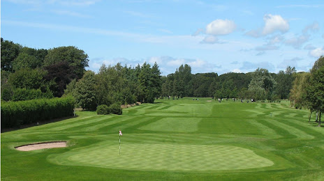
Photo
Where is located Lytham Green Drive Golf Club
Lytham Green Drive Golf Club — local attraction, which is located at Ballam Rd, Lytham Saint Annes FY8 4LE, United Kingdom and belongs to the category — golf club. Average visitor rating for this place — 4.5 (according to 131 rating, information from open sources and relevant for 2022).
Exact location — Lytham Green Drive Golf Club, marked on the map with a red marker.
You can get directions to Lytham Green Drive Golf Club on the map from your location.
What else is interesting in Southport? You can see all the sights if you go to the city page.
Coordinates
Lytham Green Drive Golf Club, United Kingdom coordinates in decimal format: latitude — 53.7460003290679, longitude — -2.960097974597011. When converted to degrees, minutes, seconds Lytham Green Drive Golf Club has the following coordinates: 53°44′45.6 north latitude and -2°57′36.35 east longitude.
Nearby cities
The largest cities that are located nearby:
- Preston — 24 km
- Liverpool — 26 km
- Blackburn — 36 km
- Manchester — 54 km
- Huddersfield — 80 km
- Stoke-on-Trent — 90 km
- Sheffield — 106 km
- Rotherham — 111 km
- Telford — 113 km
- Dudley — 140 km
- West Bromwich — 142 km
- Sutton Coldfield — 143 km
- Birmingham — 149 km
- Leicester — 168 km
- Worcester — 169 km
- Coventry — 170 km
- Sunderland — 174 km
- Cheltenham — 203 km
- Northampton — 211 km
Distance to the capital
Distance to the capital (London) is about — 314 km.