 Betteshanger
Lynton
Amesbury
Marlow
Burford
Chipping Norton
Marlborough
Cairnryan
Lydney
Betteshanger
Lynton
Amesbury
Marlow
Burford
Chipping Norton
Marlborough
Cairnryan
Lydney
Lowestoft Lighthouse on the map, Lowestoft, United Kingdom
Photo
Where is located Lowestoft Lighthouse
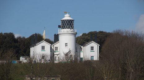
Lowestoft Lighthouse — local attraction, which is located at 3 Yarmouth Rd, Lowestoft NR32 4AN, United Kingdom and belongs to the category — lighthouse. Average visitor rating for this place — 3.8 (according to 31 rating, information from open sources and relevant for 2022).
Exact location — Lowestoft Lighthouse, marked on the map with a red marker.
You can get directions to Lowestoft Lighthouse on the map from your location.
What else is interesting in Lowestoft? You can see all the sights if you go to the city page.
Coordinates
Lowestoft Lighthouse, United Kingdom coordinates in decimal format: latitude — 52.486953113622604, longitude — 1.755820825261086. When converted to degrees, minutes, seconds Lowestoft Lighthouse has the following coordinates: 52°29′13.03 north latitude and 1°45′20.95 east longitude.
Nearby cities
The largest cities that are located nearby:
- Norwich — 35 km
- Ipswich — 62 km
- Cambridge — 115 km
- Chelmsford — 121 km
- Southend-on-Sea — 126 km
- Basildon — 133 km
- Gillingham — 147 km
- Luton — 163 km
- Watford — 173 km
- The Hague
 (Netherlands) — 179 km
 - Northampton — 182 km
- Sutton — 183 km
- Leiden (Netherlands) — 189 km
- Zoetermeer (Netherlands) — 192 km
- Slough — 194 km
- Leicester — 195 km
- Haarlem (Netherlands) — 195 km
- Rotterdam (Netherlands) — 196 km
- Hoofddorp (Netherlands) — 200 km
Distance to the capital
Distance to the capital (London) is about — 169 km.