 Betteshanger
Lynton
Amesbury
Marlow
Burford
Chipping Norton
Marlborough
Cairnryan
Lydney
Betteshanger
Lynton
Amesbury
Marlow
Burford
Chipping Norton
Marlborough
Cairnryan
Lydney
Castle Vale Park on the map, Berwick-upon-Tweed, United Kingdom
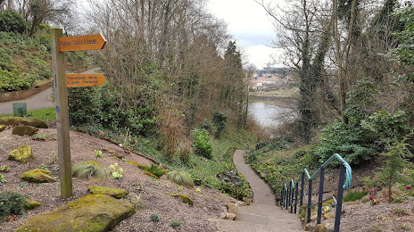
Photo
Where is located Castle Vale Park
Castle Vale Park — local attraction, which is located at 7D Railway St, Berwick-upon-Tweed TD15 1NF, United Kingdom and belongs to the category — park. Average visitor rating for this place — 4.6 (according to 12 ratings, information from open sources and relevant for 2022).
Exact location — Castle Vale Park, marked on the map with a red marker.
You can get directions to Castle Vale Park on the map from your location.
What else is interesting in Berwick-upon-Tweed? You can see all the sights if you go to the city page.
Coordinates
Castle Vale Park, United Kingdom coordinates in decimal format: latitude — 55.77318202462966, longitude — -2.0104209745192327. When converted to degrees, minutes, seconds Castle Vale Park has the following coordinates: 55°46′23.46 north latitude and -2°0′37.52 east longitude.
Nearby cities
The largest cities that are located nearby:
- Edinburgh — 76 km
- Sunderland — 103 km
- Glasgow — 140 km
- Blackburn — 226 km
- Preston — 227 km
- Huddersfield — 235 km
- Manchester — 254 km
- Rotherham — 262 km
- Sheffield — 266 km
- Liverpool — 269 km
- Belfast — 283 km
- Stoke-on-Trent — 306 km
- Telford — 343 km
- Leicester — 351 km
- Sutton Coldfield — 354 km
- West Bromwich — 360 km
- Dudley — 360 km
- Birmingham — 363 km
- Coventry — 373 km
Distance to the capital
Distance to the capital (London) is about — 490 km.