
 Staden
Geest-Gerompont-Petit-Rosière
Grote Hut
Sint-Job-in-'t-Goor
Deidenberg
De Pinte
Pussemange
Peruwelz
Barrière de Champlon
Staden
Geest-Gerompont-Petit-Rosière
Grote Hut
Sint-Job-in-'t-Goor
Deidenberg
De Pinte
Pussemange
Peruwelz
Barrière de Champlon
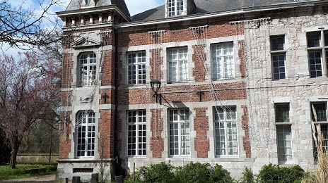
Fontaine-l'Évêque Castle on the map, Charleroi, Belgium
Photo
Where is located Fontaine-l'Évêque Castle
Fontaine-l'Évêque Castle — local attraction, which is located at frypse Castle, 6140 Fontaine-l'Évêque, Belgium and belongs to the category — castle. Average visitor rating for this place — 4.2 (according to 161 rating, information from open sources and relevant for 2022).
Exact location — Fontaine-l'Évêque Castle, marked on the map with a red marker.
You can get directions to Fontaine-l'Évêque Castle on the map from your location.
What else is interesting in Charleroi? You can see all the sights if you go to the city page.
Coordinates
Fontaine-l'Évêque Castle, Belgium coordinates in decimal format: latitude — 50.41243374978851, longitude — 4.324172798254935. When converted to degrees, minutes, seconds Fontaine-l'Évêque Castle has the following coordinates: 50°24′44.76 north latitude and 4°19′27.02 east longitude.
Nearby cities
The largest cities that are located nearby:
- Namur — 31 km
- Liège — 83 km
- Antwerp — 89 km
- Maastricht
 (Netherlands) — 100 km
 - Lille
 (France) — 100 km
 - Aachen
 (Germany) — 121 km
 - Reims (France) — 131 km
- Breda (Netherlands) — 132 km
- Eindhoven (Netherlands) — 134 km
- Tilburg (Netherlands) — 135 km
- 's-Hertogenbosch (Netherlands) — 154 km
- Dordrecht (Netherlands) — 156 km
- Mönchengladbach (Germany) — 163 km
- Amiens (France) — 163 km
- Rotterdam (Netherlands) — 167 km
- Trier (Germany) — 173 km
- Neuss (Germany) — 178 km
- Krefeld (Germany) — 180 km
- Nijmegen (Netherlands) — 182 km
Distance to the capital
Distance to the capital (Brussels) is about — 49 km.