
 Staden
Geest-Gerompont-Petit-Rosière
Grote Hut
Sint-Job-in-'t-Goor
Deidenberg
De Pinte
Pussemange
Peruwelz
Barrière de Champlon
Staden
Geest-Gerompont-Petit-Rosière
Grote Hut
Sint-Job-in-'t-Goor
Deidenberg
De Pinte
Pussemange
Peruwelz
Barrière de Champlon
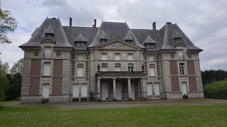
Kasteel Du Parc-Locmaria on the map, Aalst, Belgium
Photo
Where is located Kasteel Du Parc-Locmaria
Kasteel Du Parc-Locmaria — local attraction, which is located at Belgien, Herzele, Belgium and belongs to the category — park. Average visitor rating for this place — 3.6 (according to 10 ratings, information from open sources and relevant for 2022).
Exact location — Kasteel Du Parc-Locmaria, marked on the map with a red marker.
You can get directions to Kasteel Du Parc-Locmaria on the map from your location.
What else is interesting in Aalst? You can see all the sights if you go to the city page.
Coordinates
Kasteel Du Parc-Locmaria, Belgium coordinates in decimal format: latitude — 50.88551599990954, longitude — 3.902213507981405. When converted to degrees, minutes, seconds Kasteel Du Parc-Locmaria has the following coordinates: 50°53′7.86 north latitude and 3°54′7.97 east longitude.
Nearby cities
The largest cities that are located nearby:
- Antwerp — 40 km
- Charleroi — 65 km
- Lille
 (France) — 77 km
 - Namur — 78 km
- Breda
 (Netherlands) — 87 km
 - Tilburg (Netherlands) — 100 km
- Dordrecht (Netherlands) — 106 km
- Liège — 113 km
- Rotterdam (Netherlands) — 113 km
- Eindhoven (Netherlands) — 113 km
- Maastricht (Netherlands) — 116 km
- 's-Hertogenbosch (Netherlands) — 121 km
- The Hague (Netherlands) — 126 km
- Zoetermeer (Netherlands) — 128 km
- Leiden (Netherlands) — 139 km
- Aachen
 (Germany) — 144 km
 - Utrecht (Netherlands) — 147 km
- Nijmegen (Netherlands) — 156 km
- Hoofddorp (Netherlands) — 158 km
Distance to the capital
Distance to the capital (Brussels) is about — 32 km.