
 Staden
Geest-Gerompont-Petit-Rosière
Grote Hut
Sint-Job-in-'t-Goor
Deidenberg
De Pinte
Pussemange
Peruwelz
Barrière de Champlon
Staden
Geest-Gerompont-Petit-Rosière
Grote Hut
Sint-Job-in-'t-Goor
Deidenberg
De Pinte
Pussemange
Peruwelz
Barrière de Champlon
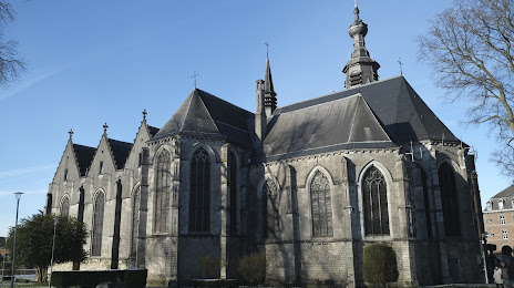
Église collégiale Saint-Ursmer on the map, Mons, Belgium
Photo
Where is located Église collégiale Saint-Ursmer
Église collégiale Saint-Ursmer — local attraction, which is located at Rue des Promenades, 7130 Binche, Belgium and belongs to the category — catholic church. Average visitor rating for this place — 4.2 (according to 78 ratings, information from open sources and relevant for 2022).
Exact location — Église collégiale Saint-Ursmer, marked on the map with a red marker.
You can get directions to Église collégiale Saint-Ursmer on the map from your location.
What else is interesting in Mons? You can see all the sights if you go to the city page.
Coordinates
Église collégiale Saint-Ursmer, Belgium coordinates in decimal format: latitude — 50.40968571755542, longitude — 4.164852607964083. When converted to degrees, minutes, seconds Église collégiale Saint-Ursmer has the following coordinates: 50°24′34.87 north latitude and 4°9′53.47 east longitude.
Nearby cities
The largest cities that are located nearby:
- Charleroi — 35 km
- Namur — 64 km
- Lille
 (France) — 66 km
 - Antwerp — 90 km
- Liège — 116 km
- Maastricht
 (Netherlands) — 129 km
 - Reims (France) — 132 km
- Amiens (France) — 134 km
- Breda (Netherlands) — 137 km
- Tilburg (Netherlands) — 145 km
- Eindhoven (Netherlands) — 151 km
- Aachen
 (Germany) — 153 km
 - Dordrecht (Netherlands) — 158 km
- 's-Hertogenbosch (Netherlands) — 166 km
- Rotterdam (Netherlands) — 166 km
- The Hague (Netherlands) — 180 km
- Zoetermeer (Netherlands) — 181 km
- Mönchengladbach (Germany) — 190 km
- Leiden (Netherlands) — 192 km
Distance to the capital
Distance to the capital (Brussels) is about — 51 km.