 Staden
Geest-Gerompont-Petit-Rosière
Grote Hut
Sint-Job-in-'t-Goor
Deidenberg
De Pinte
Pussemange
Peruwelz
Barrière de Champlon
Staden
Geest-Gerompont-Petit-Rosière
Grote Hut
Sint-Job-in-'t-Goor
Deidenberg
De Pinte
Pussemange
Peruwelz
Barrière de Champlon
Chalet-Minigolf on the map, Ostend, Belgium
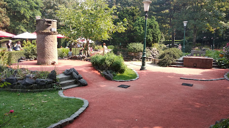
Photo
Where is located Chalet-Minigolf
Chalet-Minigolf — local attraction, which is located at Leon Spilliaertstraat 33, 8400 Oostende, Belgium and belongs to the category — $$. Average visitor rating for this place — 4.0 (according to 416 ratings, information from open sources and relevant for 2022).
Exact location — Chalet-Minigolf, marked on the map with a red marker.
You can get directions to Chalet-Minigolf on the map from your location.
What else is interesting in Ostend? You can see all the sights if you go to the city page.
Coordinates
Chalet-Minigolf, Belgium coordinates in decimal format: latitude — 51.228115749235066, longitude — 2.91295350799389. When converted to degrees, minutes, seconds Chalet-Minigolf has the following coordinates: 51°13′41.22 north latitude and 2°54′46.63 east longitude.
Nearby cities
The largest cities that are located nearby:
- Lille
 (France) — 65 km
 - Antwerp — 102 km
- Rotterdam
 (Netherlands) — 132 km
 - The Hague (Netherlands) — 133 km
- Breda (Netherlands) — 133 km
- Dordrecht (Netherlands) — 137 km
- Charleroi — 139 km
- Zoetermeer (Netherlands) — 142 km
- Leiden (Netherlands) — 149 km
- Ipswich
 (United Kingdom) — 153 km
 - Amiens (France) — 153 km
- Tilburg (Netherlands) — 154 km
- Southend-on-Sea (United Kingdom) — 157 km
- Namur — 160 km
- Gillingham (United Kingdom) — 165 km
- Hoofddorp (Netherlands) — 170 km
- 's-Hertogenbosch (Netherlands) — 171 km
- Basildon (United Kingdom) — 172 km
- Haarlem (Netherlands) — 174 km
Distance to the capital
Distance to the capital (Brussels) is about — 109 km.