
 Pfarrwerfen
Rosenau am Hengstpaß
Grinzens
Sankt Martin am Wöllmißberg
Sankt Martin am Silberberg
Söding
Felixdorf
Oberpullendorf District
Fließ
Pfarrwerfen
Rosenau am Hengstpaß
Grinzens
Sankt Martin am Wöllmißberg
Sankt Martin am Silberberg
Söding
Felixdorf
Oberpullendorf District
Fließ
Mugel on the map, Leoben, Austria
Photo
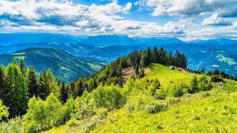
Where is located Mugel
Mugel — local attraction, which is located at 88 m and belongs to the category — -. Average visitor rating for this place — 4.5 (according to 24 ratings, information from open sources and relevant for 2022).
Exact location — Mugel, marked on the map with a red marker.
You can get directions to Mugel on the map from your location.
What else is interesting in Leoben? You can see all the sights if you go to the city page.
Coordinates
Mugel, Austria coordinates in decimal format: latitude — 47.35815140330054, longitude — 15.18832178202678. When converted to degrees, minutes, seconds Mugel has the following coordinates: 47°21′29.35 north latitude and 15°11′17.96 east longitude.
Nearby cities
The largest cities that are located nearby:
- Graz — 43 km
- Linz — 119 km
- Ljubljana
 (Slovenia) — 153 km
 - Salzburg — 159 km
- Bratislava
 (Slovakia) — 171 km
 - Zagreb
 (Croatia) — 186 km
 - Győr
 (Hungary) — 194 km
 - Trieste
 (Italy) — 216 km
 - Brno
 (Czech Republic) — 229 km
 - Rijeka (Croatia) — 232 km
- Székesfehérvár (Hungary) — 251 km
- Munich
 (Germany) — 272 km
 - Innsbruck — 277 km
- Pécs (Hungary) — 281 km
- Regensburg (Germany) — 282 km
- Pilsen (Czech Republic) — 289 km
- Olomouc (Czech Republic) — 290 km
- Budapest (Hungary) — 295 km
- Prague (Czech Republic) — 302 km
Distance to the capital
Distance to the capital (Vienna) is about — 130 km.