
 Staden
Geest-Gerompont-Petit-Rosière
Grote Hut
Sint-Job-in-'t-Goor
Deidenberg
De Pinte
Pussemange
Peruwelz
Barrière de Champlon
Staden
Geest-Gerompont-Petit-Rosière
Grote Hut
Sint-Job-in-'t-Goor
Deidenberg
De Pinte
Pussemange
Peruwelz
Barrière de Champlon
Durme on the map, Sint-Niklaas, Belgium
Photo
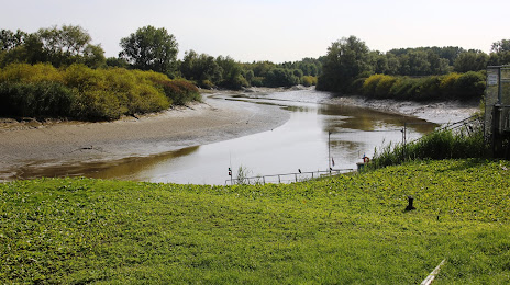
Where is located Durme
Durme — local attraction, which is located at Scheldt and belongs to the category — -. Average visitor rating for this place — 4.4 (according to 64 ratings, information from open sources and relevant for 2022).
Exact location — Durme, marked on the map with a red marker.
You can get directions to Durme on the map from your location.
What else is interesting in Sint-Niklaas? You can see all the sights if you go to the city page.
Coordinates
Durme, Belgium coordinates in decimal format: latitude — 51.178718170491386, longitude — 4.103518202968055. When converted to degrees, minutes, seconds Durme has the following coordinates: 51°10′43.39 north latitude and 4°6′12.67 east longitude.
Nearby cities
The largest cities that are located nearby:
- Antwerp — 19 km
- Breda
 (Netherlands) — 64 km
 - Tilburg (Netherlands) — 78 km
- Dordrecht (Netherlands) — 81 km
- Charleroi — 85 km
- Rotterdam (Netherlands) — 88 km
- Namur — 91 km
- Eindhoven (Netherlands) — 96 km
- Lille
 (France) — 96 km
 - 's-Hertogenbosch (Netherlands) — 99 km
- The Hague (Netherlands) — 102 km
- Zoetermeer (Netherlands) — 103 km
- Maastricht (Netherlands) — 112 km
- Leiden (Netherlands) — 113 km
- Liège — 115 km
- Utrecht (Netherlands) — 122 km
- Hoofddorp (Netherlands) — 132 km
- Nijmegen (Netherlands) — 136 km
- Amersfoort (Netherlands) — 139 km
Distance to the capital
Distance to the capital (Brussels) is about — 40 km.