
 Staden
Geest-Gerompont-Petit-Rosière
Grote Hut
Sint-Job-in-'t-Goor
Deidenberg
De Pinte
Pussemange
Peruwelz
Barrière de Champlon
Staden
Geest-Gerompont-Petit-Rosière
Grote Hut
Sint-Job-in-'t-Goor
Deidenberg
De Pinte
Pussemange
Peruwelz
Barrière de Champlon
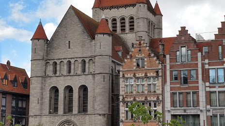
Sint-Kwintenskerk on the map, Tournai, Belgium
Photo
Where is located Sint-Kwintenskerk
Sint-Kwintenskerk — local attraction, which is located at 7500 Tournai, Belgium and belongs to the category — catholic church. Average visitor rating for this place — 4.4 (according to 64 ratings, information from open sources and relevant for 2022).
Exact location — Sint-Kwintenskerk, marked on the map with a red marker.
You can get directions to Sint-Kwintenskerk on the map from your location.
What else is interesting in Tournai? You can see all the sights if you go to the city page.
Coordinates
Sint-Kwintenskerk, Belgium coordinates in decimal format: latitude — 50.60665783472915, longitude — 3.3851060981035777. When converted to degrees, minutes, seconds Sint-Kwintenskerk has the following coordinates: 50°36′23.97 north latitude and 3°23′6.38 east longitude.
Nearby cities
The largest cities that are located nearby:
- Lille
 (France) — 23 km
 - Charleroi — 78 km
- Antwerp — 98 km
- Namur — 106 km
- Amiens (France) — 111 km
- Breda
 (Netherlands) — 144 km
 - Liège — 154 km
- Reims (France) — 156 km
- Tilburg (Netherlands) — 158 km
- Dordrecht (Netherlands) — 160 km
- Maastricht (Netherlands) — 163 km
- Rotterdam (Netherlands) — 164 km
- Eindhoven (Netherlands) — 171 km
- The Hague (Netherlands) — 173 km
- Zoetermeer (Netherlands) — 178 km
- 's-Hertogenbosch (Netherlands) — 178 km
- Leiden (Netherlands) — 188 km
- Aachen
 (Germany) — 189 km
 - Utrecht (Netherlands) — 202 km
Distance to the capital
Distance to the capital (Brussels) is about — 73 km.