
 Staden
Geest-Gerompont-Petit-Rosière
Grote Hut
Sint-Job-in-'t-Goor
Deidenberg
De Pinte
Pussemange
Peruwelz
Barrière de Champlon
Staden
Geest-Gerompont-Petit-Rosière
Grote Hut
Sint-Job-in-'t-Goor
Deidenberg
De Pinte
Pussemange
Peruwelz
Barrière de Champlon
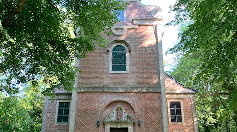
Sint-Hubertuskapel on the map, Tervuren, Belgium
Photo
Where is located Sint-Hubertuskapel
Sint-Hubertuskapel — local attraction, which is located at Kastanjedreef 23, 3080 Tervuren, Belgium and belongs to the category — catholic church. Average visitor rating for this place — 4.1 (according to 8 ratings, information from open sources and relevant for 2022).
Exact location — Sint-Hubertuskapel, marked on the map with a red marker.
You can get directions to Sint-Hubertuskapel on the map from your location.
What else is interesting in Tervuren? You can see all the sights if you go to the city page.
Coordinates
Sint-Hubertuskapel, Belgium coordinates in decimal format: latitude — 50.82406179230884, longitude — 4.517073298111469. When converted to degrees, minutes, seconds Sint-Hubertuskapel has the following coordinates: 50°49′26.62 north latitude and 4°31′1.46 east longitude.
Nearby cities
The largest cities that are located nearby:
- Antwerp — 44 km
- Charleroi — 46 km
- Namur — 47 km
- Liège — 78 km
- Maastricht
 (Netherlands) — 83 km
 - Breda (Netherlands) — 86 km
- Tilburg (Netherlands) — 91 km
- Eindhoven (Netherlands) — 95 km
- Lille
 (France) — 104 km
 - Dordrecht (Netherlands) — 110 km
- Aachen
 (Germany) — 110 km
 - 's-Hertogenbosch (Netherlands) — 111 km
- Rotterdam (Netherlands) — 121 km
- Zoetermeer (Netherlands) — 137 km
- The Hague (Netherlands) — 138 km
- Mönchengladbach (Germany) — 140 km
- Nijmegen (Netherlands) — 142 km
- Utrecht (Netherlands) — 146 km
- Leiden (Netherlands) — 148 km
Distance to the capital
Distance to the capital (Brussels) is about — 12 km.