 Betteshanger
Lynton
Amesbury
Marlow
Burford
Chipping Norton
Marlborough
Cairnryan
Lydney
Betteshanger
Lynton
Amesbury
Marlow
Burford
Chipping Norton
Marlborough
Cairnryan
Lydney
National Trust - Tintinhull Garden on the map, Yeovil, United Kingdom
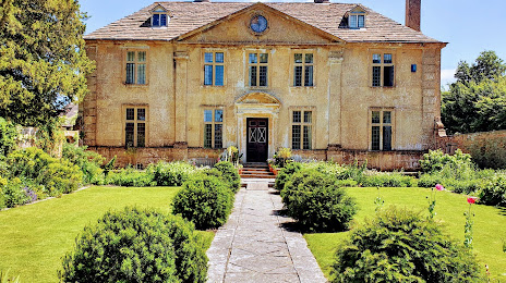
Photo
Where is located National Trust - Tintinhull Garden
National Trust - Tintinhull Garden — local attraction, which is located at Farm St, Tintinhull, Yeovil BA22 8PZ, United Kingdom and belongs to the category — $$. Average visitor rating for this place — 4.5 (according to 337 ratings, information from open sources and relevant for 2022).
Exact location — National Trust - Tintinhull Garden, marked on the map with a red marker.
You can get directions to National Trust - Tintinhull Garden on the map from your location.
What else is interesting in Yeovil? You can see all the sights if you go to the city page.
Coordinates
National Trust - Tintinhull Garden, United Kingdom coordinates in decimal format: latitude — 50.97515873382622, longitude — -2.709696001724604. When converted to degrees, minutes, seconds National Trust - Tintinhull Garden has the following coordinates: 50°58′30.57 north latitude and -2°42′34.91 east longitude.
Nearby cities
The largest cities that are located nearby:
- Bristol — 57 km
- Bournemouth — 58 km
- Exeter — 68 km
- Southampton — 86 km
- Swindon — 90 km
- Portsmouth — 109 km
- Cheltenham — 112 km
- Reading — 127 km
- Oxford — 130 km
- Worcester — 141 km
- Slough — 154 km
- Crawley — 171 km
- Watford — 173 km
- Sutton — 175 km
- Dudley — 178 km
- Birmingham — 178 km
- Coventry — 179 km
- West Bromwich — 179 km
- Luton — 183 km
Distance to the capital
Distance to the capital (London) is about — 189 km.