
 Staden
Geest-Gerompont-Petit-Rosière
Grote Hut
Sint-Job-in-'t-Goor
Deidenberg
De Pinte
Pussemange
Peruwelz
Barrière de Champlon
Staden
Geest-Gerompont-Petit-Rosière
Grote Hut
Sint-Job-in-'t-Goor
Deidenberg
De Pinte
Pussemange
Peruwelz
Barrière de Champlon
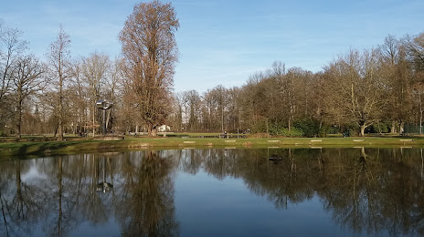
Park Olmenhof on the map, Sint-Truiden, Belgium
Photo
Where is located Park Olmenhof
Park Olmenhof — local attraction, which is located at Pikkeleerstraat 22, 3540 Herk-de-Stad, Belgium and belongs to the category — park. Average visitor rating for this place — 4.3 (according to 352 ratings, information from open sources and relevant for 2022).
Exact location — Park Olmenhof, marked on the map with a red marker.
You can get directions to Park Olmenhof on the map from your location.
What else is interesting in Sint-Truiden? You can see all the sights if you go to the city page.
Coordinates
Park Olmenhof, Belgium coordinates in decimal format: latitude — 50.93518055367, longitude — 5.167463759738341. When converted to degrees, minutes, seconds Park Olmenhof has the following coordinates: 50°56′6.65 north latitude and 5°10′2.87 east longitude.
Nearby cities
The largest cities that are located nearby:
- Liège — 34 km
- Maastricht
 (Netherlands) — 35 km
 - Namur — 44 km
- Aachen
 (Germany) — 63 km
 - Charleroi — 69 km
- Antwerp — 70 km
- Eindhoven (Netherlands) — 72 km
- Tilburg (Netherlands) — 83 km
- Breda (Netherlands) — 89 km
- Mönchengladbach (Germany) — 96 km
- 's-Hertogenbosch (Netherlands) — 98 km
- Neuss (Germany) — 113 km
- Krefeld (Germany) — 113 km
- Dordrecht (Netherlands) — 115 km
- Nijmegen (Netherlands) — 119 km
- Düsseldorf (Germany) — 119 km
- Moers (Germany) — 122 km
- Cologne (Germany) — 124 km
- Duisburg (Germany) — 128 km
Distance to the capital
Distance to the capital (Brussels) is about — 58 km.