
 Pfarrwerfen
Rosenau am Hengstpaß
Grinzens
Sankt Martin am Wöllmißberg
Sankt Martin am Silberberg
Söding
Felixdorf
Oberpullendorf District
Fließ
Pfarrwerfen
Rosenau am Hengstpaß
Grinzens
Sankt Martin am Wöllmißberg
Sankt Martin am Silberberg
Söding
Felixdorf
Oberpullendorf District
Fließ
Burgruine Neu-Montfort (Burg Neu-Montfort) on the map, Götzis, Austria
Photo
Where is located Burgruine Neu-Montfort (Burg Neu-Montfort)
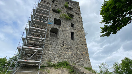
Burgruine Neu-Montfort (Burg Neu-Montfort) — local attraction, which is located at Montfortstraße, 6840 Götzis, Austria and belongs to the category — castle. Average visitor rating for this place — 4.5 (according to 62 ratings, information from open sources and relevant for 2022).
Exact location — Burgruine Neu-Montfort (Burg Neu-Montfort), marked on the map with a red marker.
You can get directions to Burgruine Neu-Montfort (Burg Neu-Montfort) on the map from your location.
What else is interesting in Götzis? You can see all the sights if you go to the city page.
Coordinates
Burgruine Neu-Montfort (Burg Neu-Montfort), Austria coordinates in decimal format: latitude — 47.328866941561, longitude — 9.644931459610202. When converted to degrees, minutes, seconds Burgruine Neu-Montfort (Burg Neu-Montfort) has the following coordinates: 47°19′43.92 north latitude and 9°38′41.75 east longitude.
Nearby cities
The largest cities that are located nearby:
- Zurich
 (Switzerland) — 83 km
 - Ulm
 (Germany) — 121 km
 - Innsbruck — 132 km
- Reutlingen (Germany) — 134 km
- Augsburg (Germany) — 147 km
- Freiburg (Germany) — 152 km
- Basel (Switzerland) — 155 km
- Stuttgart (Germany) — 163 km
- Munich (Germany) — 168 km
- Bern (Switzerland) — 172 km
- Mulhouse
 (France) — 178 km
 - Trento
 (Italy) — 180 km
 - Bergamo (Italy) — 181 km
- Pforzheim (Germany) — 186 km
- Strasbourg (France) — 195 km
- Monza (Italy) — 196 km
- Heilbronn (Germany) — 202 km
- Brescia (Italy) — 203 km
- Ingolstadt (Germany) — 205 km
Distance to the capital
Distance to the capital (Vienna) is about — 512 km.