
 Puerto de la Duquesa
La Serna de Iguña
Pumalverde
Puentenansa
La Iglesia
Casar de Periedo
Fuengirola
Renedo de Piélagos
Villabanez
Puerto de la Duquesa
La Serna de Iguña
Pumalverde
Puentenansa
La Iglesia
Casar de Periedo
Fuengirola
Renedo de Piélagos
Villabanez
Chera-Sot de Chera Natural Park on the map, Chiva, Spain
Photo
Where is located Chera-Sot de Chera Natural Park
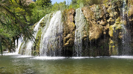
Chera-Sot de Chera Natural Park — local attraction, which is located at C. la Fuente, 54, 46350 Chera, Valencia, Spain and belongs to the category — park. Average visitor rating for this place — 4.7 (according to 1762 ratings, information from open sources and relevant for 2022).
Exact location — Chera-Sot de Chera Natural Park, marked on the map with a red marker.
You can get directions to Chera-Sot de Chera Natural Park on the map from your location.
What else is interesting in Chiva? You can see all the sights if you go to the city page.
Coordinates
Chera-Sot de Chera Natural Park, Spain coordinates in decimal format: latitude — 39.59496707658043, longitude — -0.9728880750794932. When converted to degrees, minutes, seconds Chera-Sot de Chera Natural Park has the following coordinates: 39°35′41.88 north latitude and -0°58′22.4 east longitude.
Nearby cities
The largest cities that are located nearby:
- Valencia — 29 km
- Albacete — 111 km
- Murcia — 168 km
- Cartagena — 206 km
- Zaragoza — 241 km
- Tarragona — 245 km
- Alcala de Henares — 249 km
- Torrejón de Ardoz — 256 km
- Lleida — 262 km
- Getafe — 270 km
- Alcobendas — 272 km
- Leganés — 274 km
- Fuenlabrada — 275 km
- Alcorcón — 279 km
- Móstoles — 282 km
- Palma — 287 km
- L'Hospitalet de Llobregat — 315 km
- Terrassa — 323 km
- Santa Coloma de Gramenet — 326 km
Distance to the capital
Distance to the capital (Madrid) is about — 250 km.