
 Staden
Geest-Gerompont-Petit-Rosière
Grote Hut
Sint-Job-in-'t-Goor
Deidenberg
De Pinte
Pussemange
Peruwelz
Barrière de Champlon
Staden
Geest-Gerompont-Petit-Rosière
Grote Hut
Sint-Job-in-'t-Goor
Deidenberg
De Pinte
Pussemange
Peruwelz
Barrière de Champlon
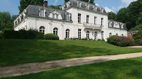
Kasteel Den Ast on the map, Deinze, Belgium
Photo
Where is located Kasteel Den Ast
Kasteel Den Ast — local attraction, which is located at Korte Aststraat 12, 9750 Zingem, Belgium and belongs to the category — castle. Average visitor rating for this place — 4.7 (according to 17 ratings, information from open sources and relevant for 2022).
Exact location — Kasteel Den Ast, marked on the map with a red marker.
You can get directions to Kasteel Den Ast on the map from your location.
What else is interesting in Deinze? You can see all the sights if you go to the city page.
Coordinates
Kasteel Den Ast, Belgium coordinates in decimal format: latitude — 50.89849402968736, longitude — 3.605932725297109. When converted to degrees, minutes, seconds Kasteel Den Ast has the following coordinates: 50°53′54.58 north latitude and 3°36′21.36 east longitude.
Nearby cities
The largest cities that are located nearby:
- Lille
 (France) — 51 km
 - Antwerp — 66 km
- Charleroi — 91 km
- Breda
 (Netherlands) — 108 km
 - Namur — 111 km
- Dordrecht (Netherlands) — 121 km
- Rotterdam (Netherlands) — 122 km
- Tilburg (Netherlands) — 125 km
- The Hague (Netherlands) — 131 km
- Zoetermeer (Netherlands) — 136 km
- Eindhoven (Netherlands) — 143 km
- 's-Hertogenbosch (Netherlands) — 145 km
- Leiden (Netherlands) — 145 km
- Amiens (France) — 149 km
- Liège — 149 km
- Maastricht (Netherlands) — 152 km
- Utrecht (Netherlands) — 163 km
- Hoofddorp (Netherlands) — 166 km
- Haarlem (Netherlands) — 172 km
Distance to the capital
Distance to the capital (Brussels) is about — 53 km.