 Betteshanger
Lynton
Amesbury
Marlow
Burford
Chipping Norton
Marlborough
Cairnryan
Lydney
Betteshanger
Lynton
Amesbury
Marlow
Burford
Chipping Norton
Marlborough
Cairnryan
Lydney
Pen Y Graig Caravan Park on the map, Aberystwyth, United Kingdom
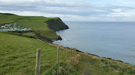
Photo
Where is located Pen Y Graig Caravan Park
Pen Y Graig Caravan Park — local attraction, which is located at Pen y Graig Caravan Park, Borth SY24 5NR, United Kingdom and belongs to the category — park. Average visitor rating for this place — 3.9 (according to 54 ratings, information from open sources and relevant for 2022).
Exact location — Pen Y Graig Caravan Park, marked on the map with a red marker.
You can get directions to Pen Y Graig Caravan Park on the map from your location.
What else is interesting in Aberystwyth? You can see all the sights if you go to the city page.
Coordinates
Pen Y Graig Caravan Park, United Kingdom coordinates in decimal format: latitude — 52.44156945263218, longitude — -4.071237435962961. When converted to degrees, minutes, seconds Pen Y Graig Caravan Park has the following coordinates: 52°26′29.65 north latitude and -4°4′16.45 east longitude.
Nearby cities
The largest cities that are located nearby:
- Telford — 114 km
- Worcester — 129 km
- Liverpool — 131 km
- Dudley — 135 km
- West Bromwich — 141 km
- Stoke-on-Trent — 142 km
- Birmingham — 148 km
- Bristol — 148 km
- Cheltenham — 148 km
- Sutton Coldfield — 153 km
- Manchester — 169 km
- Coventry — 173 km
- Preston — 174 km
- Dublin
 (Ireland) — 177 km
 - Blackburn — 181 km
- Swindon — 185 km
- Exeter — 192 km
- Leicester — 199 km
- Sheffield — 203 km
Distance to the capital
Distance to the capital (London) is about — 289 km.