
 Natal
North Jakarta
Krikilan
Kualanamu International Airport
Abdul Rachman Saleh Airport
Padang Panjang City
Lanud Wirasaba Bukateja Purbalingga
Bandara Udara Internasional ADI SOEMARMO
Ahmad Yani International Airport (SRG)
Natal
North Jakarta
Krikilan
Kualanamu International Airport
Abdul Rachman Saleh Airport
Padang Panjang City
Lanud Wirasaba Bukateja Purbalingga
Bandara Udara Internasional ADI SOEMARMO
Ahmad Yani International Airport (SRG)
Jurang gandul on the map, Ponorogo, Indonesia
Photo
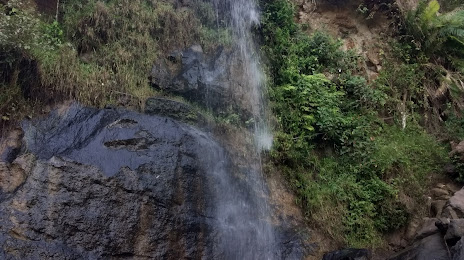
Where is located Jurang gandul
Jurang gandul — local attraction, which is located at dukuh ngrmbel rt02 rw04, Ngembel, Baosan Lor, Ngrayun, Kabupaten Ponorogo, Jawa Timur 63464, Indonesia and belongs to the category — tourist attraction. Average visitor rating for this place — 4.1 (according to 72 ratings, information from open sources and relevant for 2022).
Exact location — jurang gandul, marked on the map with a red marker.
You can get directions to Jurang gandul on the map from your location.
What else is interesting in Ponorogo? You can see all the sights if you go to the city page.
Coordinates
jurang gandul, Indonesia coordinates in decimal format: latitude — -8.09215189321419, longitude — 111.42624672432957. When converted to degrees, minutes, seconds jurang gandul has the following coordinates: -8°5′31.75 north latitude and 111°25′34.49 east longitude.
Nearby cities
The largest cities that are located nearby:
- Madiun — 27 km
- Kediri — 60 km
- Surakarta — 77 km
- Blitar — 80 km
- Klaten — 89 km
- Purwodadi — 105 km
- Mojokerto — 115 km
- Yogyakarta — 120 km
- Salatiga — 121 km
- Malang — 128 km
- Starch — 132 km
- Lawang — 135 km
- Ungaran — 141 km
- Magelang — 143 km
- Bangil — 146 km
- Sidoarjo — 148 km
- Semarang — 152 km
- Surabaya — 156 km
- Pasuruan — 159 km