 Betteshanger
Lynton
Amesbury
Marlow
Burford
Chipping Norton
Marlborough
Cairnryan
Lydney
Betteshanger
Lynton
Amesbury
Marlow
Burford
Chipping Norton
Marlborough
Cairnryan
Lydney
National Trust - Portstewart Strand on the map, Coleraine, United Kingdom
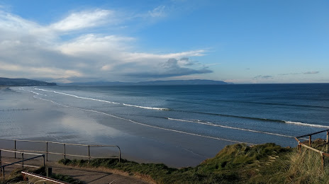
Photo
Where is located National Trust - Portstewart Strand
National Trust - Portstewart Strand — local attraction, which is located at 118 Strand Rd, Portstewart BT55 7PG, United Kingdom and belongs to the category — $$. Average visitor rating for this place — 4.7 (according to 623 ratings, information from open sources and relevant for 2022).
Exact location — National Trust - Portstewart Strand, marked on the map with a red marker.
You can get directions to National Trust - Portstewart Strand on the map from your location.
What else is interesting in Coleraine? You can see all the sights if you go to the city page.
Coordinates
National Trust - Portstewart Strand, United Kingdom coordinates in decimal format: latitude — 55.16948579609182, longitude — -6.748395132106659. When converted to degrees, minutes, seconds National Trust - Portstewart Strand has the following coordinates: 55°10′10.15 north latitude and -6°44′54.22 east longitude.
Nearby cities
The largest cities that are located nearby:
- Belfast — 76 km
- Glasgow — 170 km
- Dublin
 (Ireland) — 199 km
 - Edinburgh — 234 km
- Preston — 300 km
- Liverpool — 308 km
- Blackburn — 313 km
- Sunderland — 337 km
- Manchester — 344 km
- Huddersfield — 360 km
- Cork (Ireland) — 379 km
- Stoke-on-Trent — 380 km
- Telford — 392 km
- Sheffield — 394 km
- Rotherham — 397 km
- Dudley — 423 km
- West Bromwich — 427 km
- Sutton Coldfield — 431 km
- Birmingham — 435 km
Distance to the capital
Distance to the capital (London) is about — 599 km.