 Betteshanger
Lynton
Amesbury
Marlow
Burford
Chipping Norton
Marlborough
Cairnryan
Lydney
Betteshanger
Lynton
Amesbury
Marlow
Burford
Chipping Norton
Marlborough
Cairnryan
Lydney
All Saints' Parish Church, Ilkley on the map, Ilkley, United Kingdom
Photo
Where is located All Saints' Parish Church, Ilkley
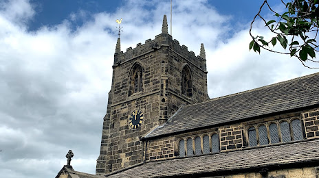
All Saints' Parish Church, Ilkley — local attraction, which is located at 4 Church St, Ilkley LS29 9DS, United Kingdom and belongs to the category — anglican church. Average visitor rating for this place — 4.6 (according to 37 ratings, information from open sources and relevant for 2022).
Exact location — All Saints' Parish Church, Ilkley, marked on the map with a red marker.
You can get directions to All Saints' Parish Church, Ilkley on the map from your location.
What else is interesting in Ilkley? You can see all the sights if you go to the city page.
Coordinates
All Saints' Parish Church, Ilkley, United Kingdom coordinates in decimal format: latitude — 53.926415751843024, longitude — -1.8241840745901847. When converted to degrees, minutes, seconds All Saints' Parish Church, Ilkley has the following coordinates: 53°55′35.1 north latitude and -1°49′27.06 east longitude.
Nearby cities
The largest cities that are located nearby:
- Huddersfield — 31 km
- Blackburn — 48 km
- Manchester — 56 km
- Preston — 60 km
- Rotherham — 62 km
- Sheffield — 65 km
- Liverpool — 96 km
- Stoke-on-Trent — 105 km
- Sunderland — 112 km
- Telford — 144 km
- Leicester — 150 km
- Sutton Coldfield — 150 km
- West Bromwich — 156 km
- Dudley — 157 km
- Birmingham — 159 km
- Coventry — 169 km
- Worcester — 193 km
- Northampton — 196 km
- Cheltenham — 225 km
Distance to the capital
Distance to the capital (London) is about — 292 km.