
 Pfarrwerfen
Rosenau am Hengstpaß
Grinzens
Sankt Martin am Wöllmißberg
Sankt Martin am Silberberg
Söding
Felixdorf
Oberpullendorf District
Fließ
Pfarrwerfen
Rosenau am Hengstpaß
Grinzens
Sankt Martin am Wöllmißberg
Sankt Martin am Silberberg
Söding
Felixdorf
Oberpullendorf District
Fließ
Modelleisenbahn Knittelfeld on the map, Knittelfeld, Austria
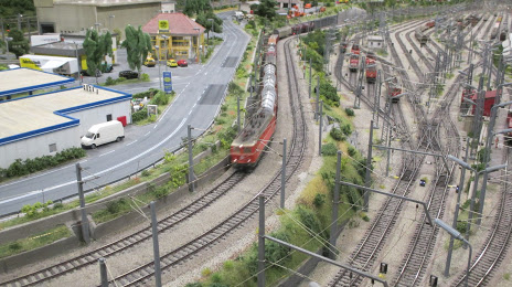
Photo
Where is located Modelleisenbahn Knittelfeld
Modelleisenbahn Knittelfeld — local attraction, which is located at Bahnhofpl. 8, 8720 Knittelfeld, Austria and belongs to the category — museum. Average visitor rating for this place — 4.7 (according to 48 ratings, information from open sources and relevant for 2022).
Exact location — Modelleisenbahn Knittelfeld, marked on the map with a red marker.
You can get directions to Modelleisenbahn Knittelfeld on the map from your location.
What else is interesting in Knittelfeld? You can see all the sights if you go to the city page.
Coordinates
Modelleisenbahn Knittelfeld, Austria coordinates in decimal format: latitude — 47.21508001456727, longitude — 14.822159615463667. When converted to degrees, minutes, seconds Modelleisenbahn Knittelfeld has the following coordinates: 47°12′54.29 north latitude and 14°49′19.77 east longitude.
Nearby cities
The largest cities that are located nearby:
- Graz — 49 km
- Linz — 127 km
- Ljubljana
 (Slovenia) — 130 km
 - Salzburg — 147 km
- Zagreb
 (Croatia) — 179 km
 - Trieste
 (Italy) — 191 km
 - Bratislava
 (Slovakia) — 197 km
 - Rijeka (Croatia) — 211 km
- Győr
 (Hungary) — 217 km
 - Brno
 (Czech Republic) — 254 km
 - Innsbruck — 257 km
- Munich
 (Germany) — 260 km
 - Székesfehérvár (Hungary) — 270 km
- Venice (Italy) — 277 km
- Regensburg (Germany) — 280 km
- Pécs (Hungary) — 290 km
- Pilsen (Czech Republic) — 298 km
- Ingolstadt (Germany) — 301 km
- Trento (Italy) — 311 km
Distance to the capital
Distance to the capital (Vienna) is about — 160 km.