
 Staden
Geest-Gerompont-Petit-Rosière
Grote Hut
Sint-Job-in-'t-Goor
Deidenberg
De Pinte
Pussemange
Peruwelz
Barrière de Champlon
Staden
Geest-Gerompont-Petit-Rosière
Grote Hut
Sint-Job-in-'t-Goor
Deidenberg
De Pinte
Pussemange
Peruwelz
Barrière de Champlon
Hoge Kempen National Park - Lieteberg (Nationaal Park Hoge Kempen - Lieteberg) on the map, Bilzen, Belgium
Photo
Where is located Hoge Kempen National Park - Lieteberg (Nationaal Park Hoge Kempen - Lieteberg)
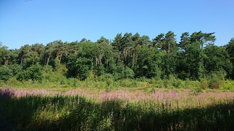
Hoge Kempen National Park - Lieteberg (Nationaal Park Hoge Kempen - Lieteberg) — local attraction, which is located at Liseveldweg, 3690 Zutendaal, Belgium and belongs to the category — national reserve. Average visitor rating for this place — 4.4 (according to 341 rating, information from open sources and relevant for 2022).
Exact location — Hoge Kempen National Park - Lieteberg (Nationaal Park Hoge Kempen - Lieteberg), marked on the map with a red marker.
You can get directions to Hoge Kempen National Park - Lieteberg (Nationaal Park Hoge Kempen - Lieteberg) on the map from your location.
What else is interesting in Bilzen? You can see all the sights if you go to the city page.
Coordinates
Hoge Kempen National Park - Lieteberg (Nationaal Park Hoge Kempen - Lieteberg), Belgium coordinates in decimal format: latitude — 50.945714593080154, longitude — 5.597277197903796. When converted to degrees, minutes, seconds Hoge Kempen National Park - Lieteberg (Nationaal Park Hoge Kempen - Lieteberg) has the following coordinates: 50°56′44.57 north latitude and 5°35′50.2 east longitude.
Nearby cities
The largest cities that are located nearby:
- Maastricht
 (Netherlands) — 12 km
 - Liège — 27 km
- Aachen
 (Germany) — 41 km
 - Eindhoven (Netherlands) — 63 km
- Namur — 64 km
- Mönchengladbach (Germany) — 73 km
- Tilburg (Netherlands) — 82 km
- Antwerp — 86 km
- Neuss (Germany) — 89 km
- Krefeld (Germany) — 90 km
- Charleroi — 91 km
- 's-Hertogenbosch (Netherlands) — 92 km
- Breda (Netherlands) — 94 km
- Düsseldorf (Germany) — 95 km
- Moers (Germany) — 101 km
- Cologne (Germany) — 101 km
- Duisburg (Germany) — 106 km
- Nijmegen (Netherlands) — 106 km
- Bonn (Germany) — 112 km
Distance to the capital
Distance to the capital (Brussels) is about — 88 km.