
 Pfarrwerfen
Rosenau am Hengstpaß
Grinzens
Sankt Martin am Wöllmißberg
Sankt Martin am Silberberg
Söding
Felixdorf
Oberpullendorf District
Fließ
Pfarrwerfen
Rosenau am Hengstpaß
Grinzens
Sankt Martin am Wöllmißberg
Sankt Martin am Silberberg
Söding
Felixdorf
Oberpullendorf District
Fließ
Persailhorn on the map, Saalfelden, Austria
Photo
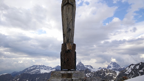
Where is located Persailhorn
Persailhorn — local attraction, which is located at 2,347 m and belongs to the category — -. Average visitor rating for this place — 4.9 (according to 12 ratings, information from open sources and relevant for 2022).
Exact location — Persailhorn, marked on the map with a red marker.
You can get directions to Persailhorn on the map from your location.
What else is interesting in Saalfelden? You can see all the sights if you go to the city page.
Coordinates
Persailhorn, Austria coordinates in decimal format: latitude — 47.459676978830785, longitude — 12.890548999716062. When converted to degrees, minutes, seconds Persailhorn has the following coordinates: 47°27′34.84 north latitude and 12°53′25.98 east longitude.
Nearby cities
The largest cities that are located nearby:
- Salzburg — 45 km
- Innsbruck — 109 km
- Munich
 (Germany) — 121 km
 - Linz — 144 km
- Augsburg (Germany) — 177 km
- Ingolstadt (Germany) — 180 km
- Regensburg (Germany) — 183 km
- Ljubljana
 (Slovenia) — 198 km
 - Graz — 200 km
- Trento
 (Italy) — 200 km
 - Trieste (Italy) — 209 km
- Venice (Italy) — 223 km
- Vicenza (Italy) — 231 km
- Ulm (Germany) — 236 km
- Nuremberg (Germany) — 257 km
- Pilsen
 (Czech Republic) — 258 km
 - Verona (Italy) — 263 km
- Fürth (Germany) — 263 km
- Rijeka
 (Croatia) — 263 km
Distance to the capital
Distance to the capital (Vienna) is about — 273 km.