
 Staden
Geest-Gerompont-Petit-Rosière
Grote Hut
Sint-Job-in-'t-Goor
Deidenberg
De Pinte
Pussemange
Peruwelz
Barrière de Champlon
Staden
Geest-Gerompont-Petit-Rosière
Grote Hut
Sint-Job-in-'t-Goor
Deidenberg
De Pinte
Pussemange
Peruwelz
Barrière de Champlon
Château de Saint-Fontaine on the map, Huy, Belgium
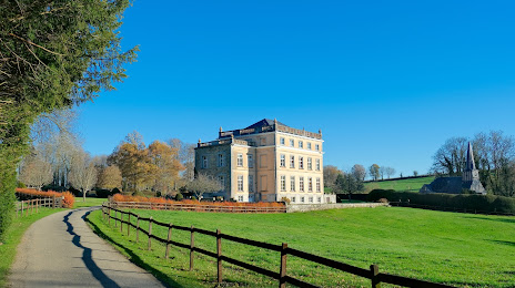
Photo
Where is located Château de Saint-Fontaine
Château de Saint-Fontaine — local attraction, which is located at Saint-Fontaine, 4560 Clavier, Belgium and belongs to the category — castle. Average visitor rating for this place — 4.7 (according to 7 ratings, information from open sources and relevant for 2022).
Exact location — Château de Saint-Fontaine, marked on the map with a red marker.
You can get directions to Château de Saint-Fontaine on the map from your location.
What else is interesting in Huy? You can see all the sights if you go to the city page.
Coordinates
Château de Saint-Fontaine, Belgium coordinates in decimal format: latitude — 50.41411941397041, longitude — 5.244257825279498. When converted to degrees, minutes, seconds Château de Saint-Fontaine has the following coordinates: 50°24′50.83 north latitude and 5°14′39.33 east longitude.
Nearby cities
The largest cities that are located nearby:
- Namur — 26 km
- Liège — 27 km
- Maastricht
 (Netherlands) — 48 km
 - Charleroi — 57 km
- Aachen
 (Germany) — 65 km
 - Antwerp — 97 km
- Eindhoven (Netherlands) — 103 km
- Mönchengladbach (Germany) — 111 km
- Tilburg (Netherlands) — 116 km
- Breda (Netherlands) — 122 km
- Neuss (Germany) — 126 km
- Cologne (Germany) — 129 km
- Krefeld (Germany) — 130 km
- 's-Hertogenbosch (Netherlands) — 130 km
- Trier (Germany) — 131 km
- Düsseldorf (Germany) — 132 km
- Bonn (Germany) — 132 km
- Moers (Germany) — 141 km
- Bergisch Gladbach (Germany) — 142 km
Distance to the capital
Distance to the capital (Brussels) is about — 79 km.