
 Puerto de la Duquesa
La Serna de Iguña
Pumalverde
Puentenansa
La Iglesia
Casar de Periedo
Fuengirola
Renedo de Piélagos
Villabanez
Puerto de la Duquesa
La Serna de Iguña
Pumalverde
Puentenansa
La Iglesia
Casar de Periedo
Fuengirola
Renedo de Piélagos
Villabanez
Platja de la Llosa on the map, Cambrils, Spain
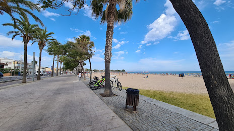
Photo
Where is located Platja de la Llosa
Platja de la Llosa — local attraction, which is located at Tarragona and belongs to the category — -. Average visitor rating for this place — 4.2 (according to 1881 rating, information from open sources and relevant for 2022).
Exact location — Platja de la Llosa, marked on the map with a red marker.
You can get directions to Platja de la Llosa on the map from your location.
What else is interesting in Cambrils? You can see all the sights if you go to the city page.
Coordinates
Platja de la Llosa, Spain coordinates in decimal format: latitude — 41.064155361842786, longitude — 1.049762886219125. When converted to degrees, minutes, seconds Platja de la Llosa has the following coordinates: 41°3′50.96 north latitude and 1°2′59.15 east longitude.
Nearby cities
The largest cities that are located nearby:
- Tarragona — 16 km
- Lleida — 71 km
- L'Hospitalet de Llobregat — 94 km
- Terrassa — 96 km
- Sabadell — 102 km
- Santa Coloma de Gramenet — 104 km
- Badalona — 107 km
- Mataró — 126 km
- Zaragoza — 173 km
- Palma — 214 km
- Valencia — 215 km
- Perpignan
 (France) — 233 km
 - Toulouse (France) — 282 km
- Pamplona — 292 km
- Logroño — 325 km
- Albacete — 340 km
- San Sebastián — 349 km
- Montpellier (France) — 360 km
- Vitoria-Gasteiz — 362 km
Distance to the capital
Distance to the capital (Madrid) is about — 407 km.